You are here: Home > Network List > UW - Pacific Northwest Regional Seismic Network Stations List
> Station HOPR Tall Timber Retreat WA > Earthquake Result Viewer
HOPR Tall Timber Retreat WA - Earthquake Result Viewer
| Earthquake location: |
Near Coast Of Nicaragua |
| Earthquake latitude/longitude: |
12.1/-87.8 |
| Earthquake time(UTC): |
2021/09/22 (265) 09:57:07 GMT |
| Earthquake Depth: |
10 km |
| Earthquake Magnitude: |
6.7 Mi |
| Earthquake Catalog/Contributor: |
NEIC PDE/at |
|
| Network: |
UW Pacific Northwest Regional Seismic Network |
| Station: |
HOPR Tall Timber Retreat WA |
| Lat/Lon: |
47.92 N/120.89 W |
| Elevation: |
597 m |
|
| Distance: |
45.1 deg |
| Az: |
328.8 deg |
| Baz: |
131.124 deg |
| Ray Param: |
0.0714759 |
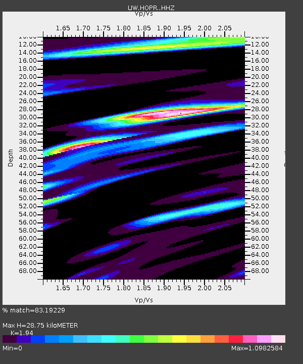
| Estimated Moho Depth: |
28.75 km |
| Estimated Crust Vp/Vs: |
1.94 |
| Assumed Crust Vp: |
6.597 km/s |
| Estimated Crust Vs: |
3.401 km/s |
| Estimated Crust Poisson's Ratio: |
0.32 |
|
| Radial Match: |
83.19229 % |
| Radial Bump: |
400 |
| Transverse Match: |
79.07143 % |
| Transverse Bump: |
400 |
| SOD ConfigId: |
25131211 |
| Insert Time: |
2021-10-06 10:26:15.222 +0000 |
| GWidth: |
2.5 |
| Max Bumps: |
400 |
| Tol: |
0.001 |
|

Signal To Noise
| Channel | StoN | STA | LTA |
| UW:HOPR: :HHZ:20210922T10:04:52.750Z | 24.691814 | 2.9251644E-6 | 1.1846697E-7 |
| UW:HOPR: :HHN:20210922T10:04:52.750Z | 6.7299886 | 1.037531E-6 | 1.5416533E-7 |
| UW:HOPR: :HHE:20210922T10:04:52.750Z | 16.009802 | 2.145741E-6 | 1.3402672E-7 |
| Arrivals |
| Ps | 4.4 SECOND |
| PpPs | 12 SECOND |
| PsPs/PpSs | 16 SECOND |


