You are here: Home > Network List > UW - Pacific Northwest Regional Seismic Network Stations List
> Station MANO Manastash Observatory, WA, USA > Earthquake Result Viewer
MANO Manastash Observatory, WA, USA - Earthquake Result Viewer
| Earthquake location: |
Near Coast Of Nicaragua |
| Earthquake latitude/longitude: |
12.1/-87.8 |
| Earthquake time(UTC): |
2021/09/22 (265) 09:57:07 GMT |
| Earthquake Depth: |
10 km |
| Earthquake Magnitude: |
6.7 Mi |
| Earthquake Catalog/Contributor: |
NEIC PDE/at |
|
| Network: |
UW Pacific Northwest Regional Seismic Network |
| Station: |
MANO Manastash Observatory, WA, USA |
| Lat/Lon: |
46.95 N/120.72 W |
| Elevation: |
1200 m |
|
| Distance: |
44.4 deg |
| Az: |
327.863 deg |
| Baz: |
130.583 deg |
| Ray Param: |
0.07194011 |
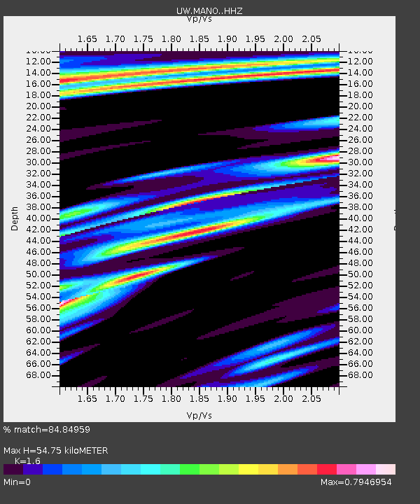
| Estimated Moho Depth: |
54.75 km |
| Estimated Crust Vp/Vs: |
1.60 |
| Assumed Crust Vp: |
6.597 km/s |
| Estimated Crust Vs: |
4.123 km/s |
| Estimated Crust Poisson's Ratio: |
0.18 |
|
| Radial Match: |
84.84959 % |
| Radial Bump: |
343 |
| Transverse Match: |
58.22975 % |
| Transverse Bump: |
400 |
| SOD ConfigId: |
25131211 |
| Insert Time: |
2021-10-06 10:26:39.408 +0000 |
| GWidth: |
2.5 |
| Max Bumps: |
400 |
| Tol: |
0.001 |
|

Signal To Noise
| Channel | StoN | STA | LTA |
| UW:MANO: :HHZ:20210922T10:04:46.98999Z | 25.092512 | 4.8355732E-6 | 1.927098E-7 |
| UW:MANO: :HHN:20210922T10:04:46.98999Z | 14.898879 | 1.7111303E-6 | 1.148496E-7 |
| UW:MANO: :HHE:20210922T10:04:46.98999Z | 6.393042 | 1.167389E-6 | 1.8260305E-7 |
| Arrivals |
| Ps | 5.4 SECOND |
| PpPs | 20 SECOND |
| PsPs/PpSs | 25 SECOND |


