You are here: Home > Network List > US - United States National Seismic Network Stations List
> Station DGMT Dagmar, Montana, USA > Earthquake Result Viewer
DGMT Dagmar, Montana, USA - Earthquake Result Viewer
*The percent match for this event was below the threshold and hence no stack was calculated.
| Earthquake location: |
Near Coast Of Nicaragua |
| Earthquake latitude/longitude: |
12.1/-87.7 |
| Earthquake time(UTC): |
2021/09/22 (265) 12:57:00 GMT |
| Earthquake Depth: |
33 km |
| Earthquake Magnitude: |
5.6 mww |
| Earthquake Catalog/Contributor: |
NEIC PDE/us |
|
| Network: |
US United States National Seismic Network |
| Station: |
DGMT Dagmar, Montana, USA |
| Lat/Lon: |
48.47 N/104.20 W |
| Elevation: |
0.0 m |
|
| Distance: |
38.8 deg |
| Az: |
342.43 deg |
| Baz: |
153.659 deg |
| Ray Param: |
$rayparam |
*The percent match for this event was below the threshold and hence was not used in the summary stack. |
|
| Radial Match: |
61.067314 % |
| Radial Bump: |
378 |
| Transverse Match: |
65.74287 % |
| Transverse Bump: |
381 |
| SOD ConfigId: |
25131211 |
| Insert Time: |
2021-10-06 13:14:05.637 +0000 |
| GWidth: |
2.5 |
| Max Bumps: |
400 |
| Tol: |
0.001 |
|
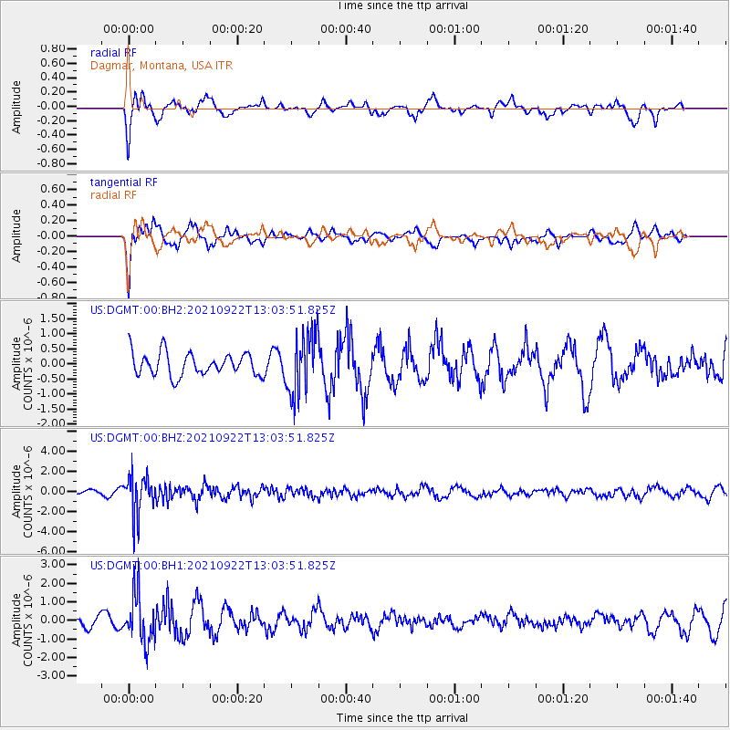
Signal To Noise
| Channel | StoN | STA | LTA |
| US:DGMT:00:BHZ:20210922T13:03:51.825Z | 8.736346 | 1.9633137E-6 | 2.247294E-7 |
| US:DGMT:00:BH1:20210922T13:03:51.825Z | 2.9296107 | 1.3098098E-6 | 4.4709344E-7 |
| US:DGMT:00:BH2:20210922T13:03:51.825Z | 2.7349153 | 1.0275124E-6 | 3.7570175E-7 |
| Arrivals |
| Ps | |
| PpPs | |
| PsPs/PpSs | |


