You are here: Home > Network List > AK - Alaska Regional Network Stations List
> Station PAX Paxson > Earthquake Result Viewer
PAX Paxson - Earthquake Result Viewer
| Earthquake location: |
Kermadec Islands Region |
| Earthquake latitude/longitude: |
-27.4/-176.3 |
| Earthquake time(UTC): |
2009/02/18 (049) 21:53:45 GMT |
| Earthquake Depth: |
25 km |
| Earthquake Magnitude: |
6.8 MB, 7.2 MS, 6.9 MW, 6.9 MW |
| Earthquake Catalog/Contributor: |
WHDF/NEIC |
|
| Network: |
AK Alaska Regional Network |
| Station: |
PAX Paxson |
| Lat/Lon: |
62.97 N/145.47 W |
| Elevation: |
1130 m |
|
| Distance: |
93.4 deg |
| Az: |
13.578 deg |
| Baz: |
207.179 deg |
| Ray Param: |
0.041265693 |
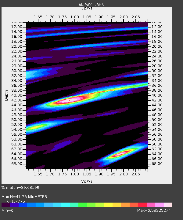
| Estimated Moho Depth: |
41.75 km |
| Estimated Crust Vp/Vs: |
1.78 |
| Assumed Crust Vp: |
6.566 km/s |
| Estimated Crust Vs: |
3.694 km/s |
| Estimated Crust Poisson's Ratio: |
0.27 |
|
| Radial Match: |
89.08199 % |
| Radial Bump: |
400 |
| Transverse Match: |
87.96334 % |
| Transverse Bump: |
274 |
| SOD ConfigId: |
2658 |
| Insert Time: |
2010-03-09 12:58:41.080 +0000 |
| GWidth: |
2.5 |
| Max Bumps: |
400 |
| Tol: |
0.001 |
|

Signal To Noise
| Channel | StoN | STA | LTA |
| AK:PAX: :BHN:20090218T22:06:26.527004Z | 3.551267 | 5.488296E-7 | 1.5454472E-7 |
| AK:PAX: :BHE:20090218T22:06:26.527004Z | 1.5079473 | 2.38126E-7 | 1.5791402E-7 |
| AK:PAX: :BHZ:20090218T22:06:26.527004Z | 0.78903735 | 1.2137176E-7 | 1.5382257E-7 |
| Arrivals |
| Ps | 5.0 SECOND |
| PpPs | 17 SECOND |
| PsPs/PpSs | 22 SECOND |


