You are here: Home > Network List > US - United States National Seismic Network Stations List
> Station MSO Missoula, Montana, USA > Earthquake Result Viewer
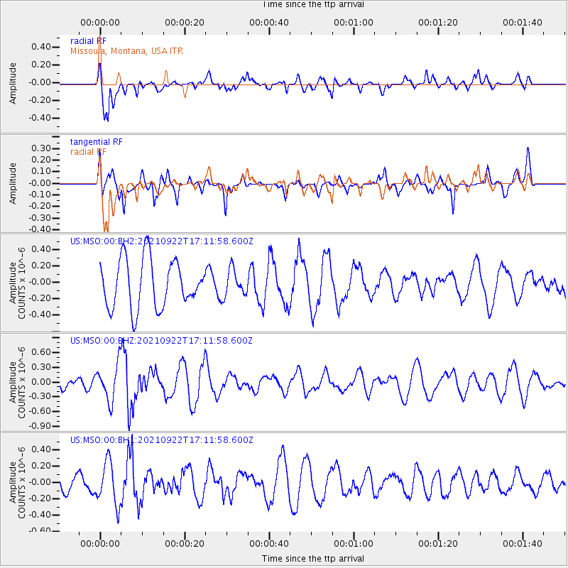
MSO Missoula, Montana, USA - Earthquake Result Viewer
*The percent match for this event was below the threshold and hence no stack was calculated.
| Earthquake location: |
East Of Lake Baykal, Russia |
| Earthquake latitude/longitude: |
56.4/117.8 |
| Earthquake time(UTC): |
2021/09/22 (265) 17:01:27 GMT |
| Earthquake Depth: |
10 km |
| Earthquake Magnitude: |
5.5 mb |
| Earthquake Catalog/Contributor: |
NEIC PDE/us |
|
| Network: |
US United States National Seismic Network |
| Station: |
MSO Missoula, Montana, USA |
| Lat/Lon: |
46.83 N/113.94 W |
| Elevation: |
1264 m |
|
| Distance: |
68.4 deg |
| Az: |
35.413 deg |
| Baz: |
332.031 deg |
| Ray Param: |
$rayparam |
*The percent match for this event was below the threshold and hence was not used in the summary stack. |
|
| Radial Match: |
78.179306 % |
| Radial Bump: |
400 |
| Transverse Match: |
66.70142 % |
| Transverse Bump: |
400 |
| SOD ConfigId: |
25131211 |
| Insert Time: |
2021-10-06 17:21:34.779 +0000 |
| GWidth: |
2.5 |
| Max Bumps: |
400 |
| Tol: |
0.001 |
|
Signal To Noise
| Channel | StoN | STA | LTA |
| US:MSO:00:BHZ:20210922T17:11:58.600Z | 1.8229495 | 3.8682893E-7 | 2.1219947E-7 |
| US:MSO:00:BH1:20210922T17:11:58.600Z | 1.6981299 | 2.6844833E-7 | 1.5808469E-7 |
| US:MSO:00:BH2:20210922T17:11:58.600Z | 0.54787284 | 1.612445E-7 | 2.9431007E-7 |
| Arrivals |
| Ps | |
| PpPs | |
| PsPs/PpSs | |


