You are here: Home > Network List > AV - Alaska Volcano Observatory Stations List
> Station SPU Mount Spurr, Mount Spurr, Alaska > Earthquake Result Viewer
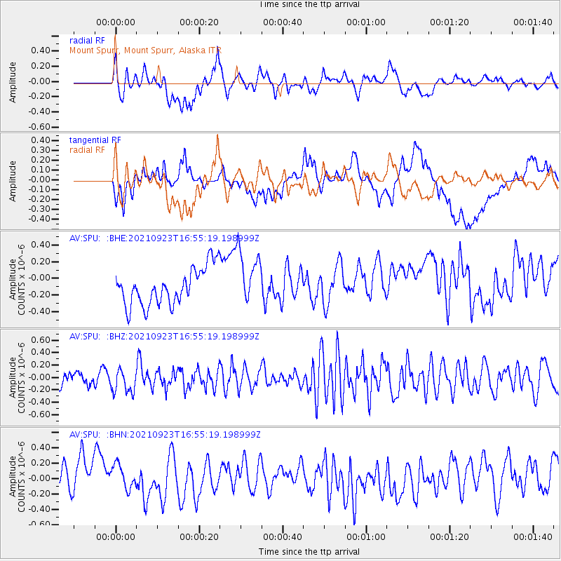
SPU Mount Spurr, Mount Spurr, Alaska - Earthquake Result Viewer
*The percent match for this event was below the threshold and hence no stack was calculated.
| Earthquake location: |
Gulf Of California |
| Earthquake latitude/longitude: |
23.2/-108.1 |
| Earthquake time(UTC): |
2021/09/23 (266) 16:47:07 GMT |
| Earthquake Depth: |
10 km |
| Earthquake Magnitude: |
5.2 mb |
| Earthquake Catalog/Contributor: |
NEIC PDE/us |
|
| Network: |
AV Alaska Volcano Observatory |
| Station: |
SPU Mount Spurr, Mount Spurr, Alaska |
| Lat/Lon: |
61.18 N/152.06 W |
| Elevation: |
800 m |
|
| Distance: |
48.4 deg |
| Az: |
333.283 deg |
| Baz: |
121.37 deg |
| Ray Param: |
$rayparam |
*The percent match for this event was below the threshold and hence was not used in the summary stack. |
|
| Radial Match: |
57.02554 % |
| Radial Bump: |
400 |
| Transverse Match: |
35.150093 % |
| Transverse Bump: |
400 |
| SOD ConfigId: |
25131211 |
| Insert Time: |
2021-10-07 16:50:19.097 +0000 |
| GWidth: |
2.5 |
| Max Bumps: |
400 |
| Tol: |
0.001 |
|
Signal To Noise
| Channel | StoN | STA | LTA |
| AV:SPU: :BHZ:20210923T16:55:19.198999Z | 1.5114747 | 1.9479621E-7 | 1.2887824E-7 |
| AV:SPU: :BHN:20210923T16:55:19.198999Z | 0.82406324 | 2.1716326E-7 | 2.6352743E-7 |
| AV:SPU: :BHE:20210923T16:55:19.198999Z | 1.4533323 | 3.2408113E-7 | 2.2299177E-7 |
| Arrivals |
| Ps | |
| PpPs | |
| PsPs/PpSs | |


