You are here: Home > Network List > AK - Alaska Regional Network Stations List
> Station E27K Coleen River, AK, USA > Earthquake Result Viewer
E27K Coleen River, AK, USA - Earthquake Result Viewer
| Earthquake location: |
Gulf Of California |
| Earthquake latitude/longitude: |
23.0/-107.9 |
| Earthquake time(UTC): |
2021/09/23 (266) 16:47:48 GMT |
| Earthquake Depth: |
10 km |
| Earthquake Magnitude: |
5.7 Mwb |
| Earthquake Catalog/Contributor: |
NEIC PDE/us |
|
| Network: |
AK Alaska Regional Network |
| Station: |
E27K Coleen River, AK, USA |
| Lat/Lon: |
68.19 N/141.60 W |
| Elevation: |
654 m |
|
| Distance: |
49.7 deg |
| Az: |
344.235 deg |
| Baz: |
137.947 deg |
| Ray Param: |
0.06856254 |
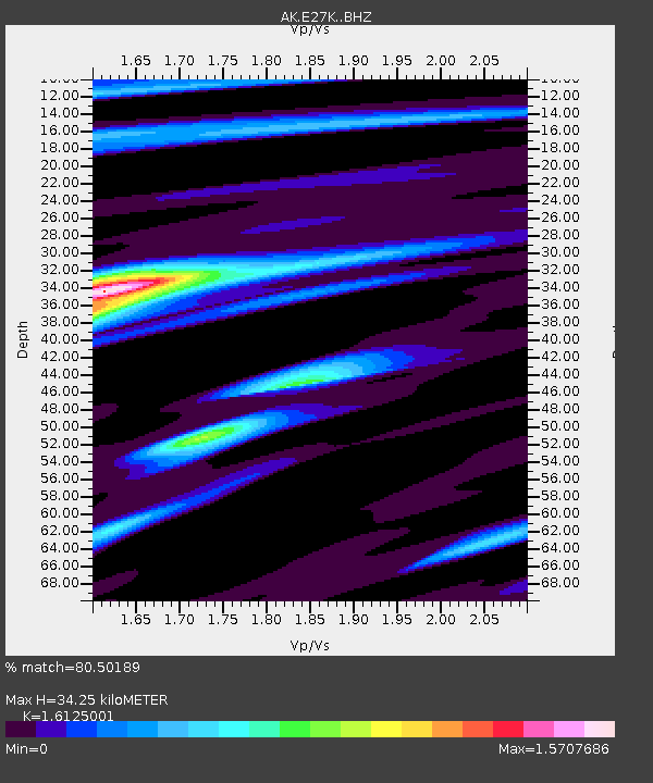
| Estimated Moho Depth: |
34.25 km |
| Estimated Crust Vp/Vs: |
1.61 |
| Assumed Crust Vp: |
6.522 km/s |
| Estimated Crust Vs: |
4.044 km/s |
| Estimated Crust Poisson's Ratio: |
0.19 |
|
| Radial Match: |
80.50189 % |
| Radial Bump: |
343 |
| Transverse Match: |
65.74349 % |
| Transverse Bump: |
400 |
| SOD ConfigId: |
25131211 |
| Insert Time: |
2021-10-07 16:58:13.338 +0000 |
| GWidth: |
2.5 |
| Max Bumps: |
400 |
| Tol: |
0.001 |
|

Signal To Noise
| Channel | StoN | STA | LTA |
| AK:E27K: :BHZ:20210923T16:56:09.939987Z | 1.7454178 | 3.5351695E-7 | 2.0254002E-7 |
| AK:E27K: :BHN:20210923T16:56:09.939987Z | 2.4466982 | 2.7859605E-7 | 1.1386612E-7 |
| AK:E27K: :BHE:20210923T16:56:09.939987Z | 1.2926648 | 1.8434953E-7 | 1.4261201E-7 |
| Arrivals |
| Ps | 3.4 SECOND |
| PpPs | 13 SECOND |
| PsPs/PpSs | 16 SECOND |


