You are here: Home > Network List > CN - Canadian National Seismograph Network Stations List
> Station INK INUVIK, NT > Earthquake Result Viewer
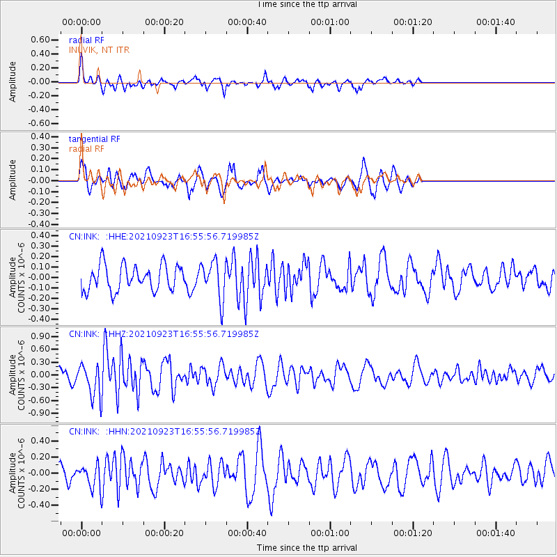
INK INUVIK, NT - Earthquake Result Viewer
*The percent match for this event was below the threshold and hence no stack was calculated.
| Earthquake location: |
Gulf Of California |
| Earthquake latitude/longitude: |
23.0/-107.9 |
| Earthquake time(UTC): |
2021/09/23 (266) 16:47:48 GMT |
| Earthquake Depth: |
10 km |
| Earthquake Magnitude: |
5.7 Mwb |
| Earthquake Catalog/Contributor: |
NEIC PDE/us |
|
| Network: |
CN Canadian National Seismograph Network |
| Station: |
INK INUVIK, NT |
| Lat/Lon: |
68.31 N/133.53 W |
| Elevation: |
44 m |
|
| Distance: |
48.0 deg |
| Az: |
347.512 deg |
| Baz: |
147.595 deg |
| Ray Param: |
$rayparam |
*The percent match for this event was below the threshold and hence was not used in the summary stack. |
|
| Radial Match: |
65.36205 % |
| Radial Bump: |
331 |
| Transverse Match: |
64.411934 % |
| Transverse Bump: |
377 |
| SOD ConfigId: |
25131211 |
| Insert Time: |
2021-10-07 17:02:04.336 +0000 |
| GWidth: |
2.5 |
| Max Bumps: |
400 |
| Tol: |
0.001 |
|
Signal To Noise
| Channel | StoN | STA | LTA |
| CN:INK: :HHZ:20210923T16:55:56.719985Z | 2.7580376 | 3.8540023E-7 | 1.3973712E-7 |
| CN:INK: :HHN:20210923T16:55:56.719985Z | 1.0622174 | 1.4545869E-7 | 1.3693874E-7 |
| CN:INK: :HHE:20210923T16:55:56.719985Z | 1.5318664 | 1.8802075E-7 | 1.2273965E-7 |
| Arrivals |
| Ps | |
| PpPs | |
| PsPs/PpSs | |


