You are here: Home > Network List > AG - Arkansas Seismic Network Stations List
> Station WHAR Woolly Hollow State Park,AR > Earthquake Result Viewer
WHAR Woolly Hollow State Park,AR - Earthquake Result Viewer
| Earthquake location: |
Andreanof Islands, Aleutian Is. |
| Earthquake latitude/longitude: |
51.1/-178.9 |
| Earthquake time(UTC): |
2021/09/24 (267) 11:52:31 GMT |
| Earthquake Depth: |
50 km |
| Earthquake Magnitude: |
6.3 Mi |
| Earthquake Catalog/Contributor: |
NEIC PDE/at |
|
| Network: |
AG Arkansas Seismic Network |
| Station: |
WHAR Woolly Hollow State Park,AR |
| Lat/Lon: |
35.29 N/92.29 W |
| Elevation: |
184 m |
|
| Distance: |
61.6 deg |
| Az: |
68.24 deg |
| Baz: |
314.228 deg |
| Ray Param: |
0.06069232 |
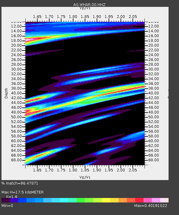
| Estimated Moho Depth: |
17.5 km |
| Estimated Crust Vp/Vs: |
1.60 |
| Assumed Crust Vp: |
6.498 km/s |
| Estimated Crust Vs: |
4.061 km/s |
| Estimated Crust Poisson's Ratio: |
0.18 |
|
| Radial Match: |
96.47871 % |
| Radial Bump: |
294 |
| Transverse Match: |
86.659164 % |
| Transverse Bump: |
299 |
| SOD ConfigId: |
25131211 |
| Insert Time: |
2021-10-08 11:54:33.033 +0000 |
| GWidth: |
2.5 |
| Max Bumps: |
400 |
| Tol: |
0.001 |
|

Signal To Noise
| Channel | StoN | STA | LTA |
| AG:WHAR:00:HHZ:20210924T12:02:12.335022Z | 37.463783 | 4.0066006E-6 | 1.06945976E-7 |
| AG:WHAR:00:HHN:20210924T12:02:12.335022Z | 11.016342 | 1.1041766E-6 | 1.0023078E-7 |
| AG:WHAR:00:HHE:20210924T12:02:12.335022Z | 9.862857 | 1.188211E-6 | 1.204733E-7 |
| Arrivals |
| Ps | 1.7 SECOND |
| PpPs | 6.7 SECOND |
| PsPs/PpSs | 8.4 SECOND |


