You are here: Home > Network List > CC - Cascade Chain Volcano Monitoring Stations List
> Station LSON Lamberson Butte > Earthquake Result Viewer
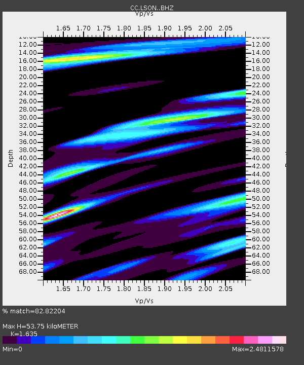
LSON Lamberson Butte - Earthquake Result Viewer
| Earthquake location: |
Andreanof Islands, Aleutian Is. |
| Earthquake latitude/longitude: |
51.1/-178.9 |
| Earthquake time(UTC): |
2021/09/24 (267) 11:52:31 GMT |
| Earthquake Depth: |
50 km |
| Earthquake Magnitude: |
6.3 Mi |
| Earthquake Catalog/Contributor: |
NEIC PDE/at |
|
| Network: |
CC Cascade Chain Volcano Monitoring |
| Station: |
LSON Lamberson Butte |
| Lat/Lon: |
45.36 N/121.65 W |
| Elevation: |
1881 m |
|
| Distance: |
37.8 deg |
| Az: |
75.617 deg |
| Baz: |
299.869 deg |
| Ray Param: |
0.07581872 |
| Estimated Moho Depth: |
53.75 km |
| Estimated Crust Vp/Vs: |
1.63 |
| Assumed Crust Vp: |
6.597 km/s |
| Estimated Crust Vs: |
4.035 km/s |
| Estimated Crust Poisson's Ratio: |
0.20 |
|
| Radial Match: |
82.82204 % |
| Radial Bump: |
400 |
| Transverse Match: |
77.38001 % |
| Transverse Bump: |
400 |
| SOD ConfigId: |
25131211 |
| Insert Time: |
2021-10-08 11:57:36.992 +0000 |
| GWidth: |
2.5 |
| Max Bumps: |
400 |
| Tol: |
0.001 |
|

Signal To Noise
| Channel | StoN | STA | LTA |
| CC:LSON: :BHZ:20210924T11:59:11.859985Z | 14.868591 | 2.6669793E-6 | 1.7937E-7 |
| CC:LSON: :BHN:20210924T11:59:11.859985Z | 2.025914 | 7.6054647E-7 | 3.7540906E-7 |
| CC:LSON: :BHE:20210924T11:59:11.859985Z | 3.3542202 | 1.482253E-6 | 4.4190688E-7 |
| Arrivals |
| Ps | 5.6 SECOND |
| PpPs | 20 SECOND |
| PsPs/PpSs | 25 SECOND |


