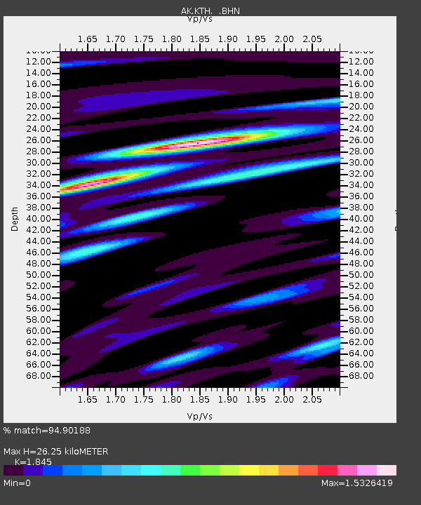
KTH Kantishna Hills - Earthquake Result Viewer

Earthquake location: Near East Coast Of Honshu, Japan
Earthquake latitude/longitude: 38.3/142.0
Earthquake time(UTC): 2005/08/16 (228) 02:46:28 GMT
Earthquake Depth: 36 km
Earthquake Magnitude: 6.5 MB, 6.8 MS, 7.2 MW, 7.1 MW
Earthquake Catalog/Contributor: WHDF/NEIC
Network: AK Alaska Regional Network
Station: KTH Kantishna Hills
Lat/Lon: 63.55 N/150.92 W
Elevation: 1172 m
Distance: 46.4 deg
Az: 34.675 deg
Baz: 270.134 deg
Ray Param: 0.07056779
Estimated Moho Depth: 26.25 km
Estimated Crust Vp/Vs: 1.85
Assumed Crust Vp: 6.438 km/s
Estimated Crust Vs: 3.49 km/s
Estimated Crust Poisson's Ratio: 0.29
Radial Match: 94.90188 %
Radial Bump: 322
Transverse Match: 89.343315 %
Transverse Bump: 387
SOD ConfigId: 2475
Insert Time: 2010-03-09 13:00:47.593 +0000
GWidth: 2.5
Max Bumps: 400
Tol: 0.001

Signal To Noise

ChannelStoNSTALTA
AK:KTH: :BHN:20050816T02:54:21.199011Z2.2814921.0633752E-74.660876E-8
AK:KTH: :BHE:20050816T02:54:21.199011Z16.3207639.474809E-75.805371E-8
AK:KTH: :BHZ:20050816T02:54:21.199011Z35.7352261.6912005E-64.7325866E-8
Arrivals
Ps3.7 SECOND
PpPs11 SECOND
PsPs/PpSs15 SECOND