You are here: Home > Network List > AK - Alaska Regional Network Stations List
> Station KTH Kantishna Hills > Earthquake Result Viewer
KTH Kantishna Hills - Earthquake Result Viewer
| Earthquake location: |
Southern Xinjiang, China |
| Earthquake latitude/longitude: |
35.5/81.5 |
| Earthquake time(UTC): |
2008/03/20 (080) 22:32:57 GMT |
| Earthquake Depth: |
10 km |
| Earthquake Magnitude: |
6.3 MB, 7.3 MS, 7.2 MW, 7.1 MW |
| Earthquake Catalog/Contributor: |
WHDF/NEIC |
|
| Network: |
AK Alaska Regional Network |
| Station: |
KTH Kantishna Hills |
| Lat/Lon: |
63.55 N/150.92 W |
| Elevation: |
1172 m |
|
| Distance: |
72.9 deg |
| Az: |
21.782 deg |
| Baz: |
317.446 deg |
| Ray Param: |
0.053347286 |
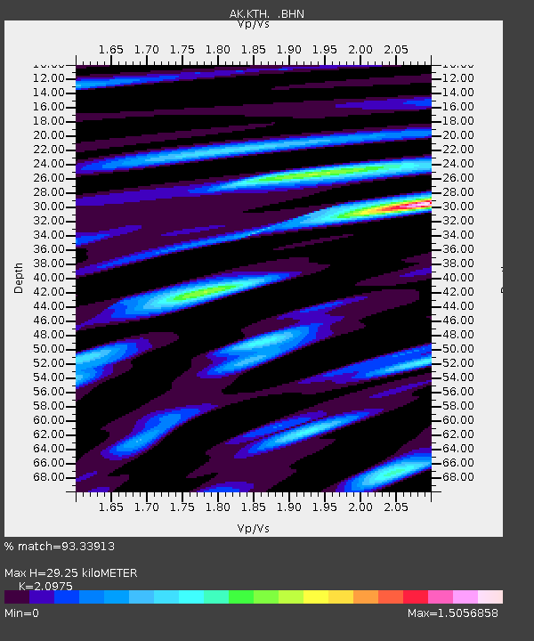
| Estimated Moho Depth: |
29.25 km |
| Estimated Crust Vp/Vs: |
2.10 |
| Assumed Crust Vp: |
6.438 km/s |
| Estimated Crust Vs: |
3.069 km/s |
| Estimated Crust Poisson's Ratio: |
0.35 |
|
| Radial Match: |
93.33913 % |
| Radial Bump: |
400 |
| Transverse Match: |
77.39566 % |
| Transverse Bump: |
400 |
| SOD ConfigId: |
2564 |
| Insert Time: |
2010-03-09 13:01:00.185 +0000 |
| GWidth: |
2.5 |
| Max Bumps: |
400 |
| Tol: |
0.001 |
|

Signal To Noise
| Channel | StoN | STA | LTA |
| AK:KTH: :BHN:20080320T22:43:55.898018Z | 1.107043 | 2.9067937E-7 | 2.6257277E-7 |
| AK:KTH: :BHE:20080320T22:43:55.898018Z | 0.9073008 | 1.6790942E-7 | 1.8506479E-7 |
| AK:KTH: :BHZ:20080320T22:43:55.898018Z | 5.765554 | 7.6254463E-7 | 1.3225869E-7 |
| Arrivals |
| Ps | 5.1 SECOND |
| PpPs | 14 SECOND |
| PsPs/PpSs | 19 SECOND |


