You are here: Home > Network List > GM - US Geological Survey Networks Stations List
> Station NMP11 New Mexico Permian - Site# W1S1 > Earthquake Result Viewer
NMP11 New Mexico Permian - Site# W1S1 - Earthquake Result Viewer
| Earthquake location: |
Andreanof Islands, Aleutian Is. |
| Earthquake latitude/longitude: |
51.1/-178.9 |
| Earthquake time(UTC): |
2021/09/24 (267) 11:52:31 GMT |
| Earthquake Depth: |
50 km |
| Earthquake Magnitude: |
6.3 Mi |
| Earthquake Catalog/Contributor: |
NEIC PDE/at |
|
| Network: |
GM US Geological Survey Networks |
| Station: |
NMP11 New Mexico Permian - Site# W1S1 |
| Lat/Lon: |
32.01 N/103.93 W |
| Elevation: |
883 m |
|
| Distance: |
56.8 deg |
| Az: |
78.8 deg |
| Baz: |
313.217 deg |
| Ray Param: |
0.06379431 |
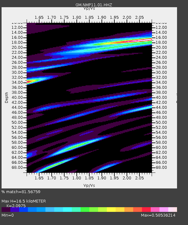
| Estimated Moho Depth: |
16.5 km |
| Estimated Crust Vp/Vs: |
2.10 |
| Assumed Crust Vp: |
6.129 km/s |
| Estimated Crust Vs: |
2.922 km/s |
| Estimated Crust Poisson's Ratio: |
0.35 |
|
| Radial Match: |
81.56759 % |
| Radial Bump: |
400 |
| Transverse Match: |
70.86308 % |
| Transverse Bump: |
400 |
| SOD ConfigId: |
25131211 |
| Insert Time: |
2021-10-08 12:04:46.563 +0000 |
| GWidth: |
2.5 |
| Max Bumps: |
400 |
| Tol: |
0.001 |
|

Signal To Noise
| Channel | StoN | STA | LTA |
| GM:NMP11:01:HHZ:20210924T12:01:39.38501Z | 4.296963 | 9.2851576E-7 | 2.160865E-7 |
| GM:NMP11:01:HHN:20210924T12:01:39.38501Z | 1.6106751 | 2.4955506E-7 | 1.5493818E-7 |
| GM:NMP11:01:HHE:20210924T12:01:39.38501Z | 5.1923537 | 4.6214126E-7 | 8.9004196E-8 |
| Arrivals |
| Ps | 3.1 SECOND |
| PpPs | 8.0 SECOND |
| PsPs/PpSs | 11 SECOND |


