You are here: Home > Network List > GS - US Geological Survey Networks Stations List
> Station KS28 W Mills Ave, Hutchinson KS > Earthquake Result Viewer
KS28 W Mills Ave, Hutchinson KS - Earthquake Result Viewer
| Earthquake location: |
Andreanof Islands, Aleutian Is. |
| Earthquake latitude/longitude: |
51.1/-178.9 |
| Earthquake time(UTC): |
2021/09/24 (267) 11:52:31 GMT |
| Earthquake Depth: |
50 km |
| Earthquake Magnitude: |
6.3 Mi |
| Earthquake Catalog/Contributor: |
NEIC PDE/at |
|
| Network: |
GS US Geological Survey Networks |
| Station: |
KS28 W Mills Ave, Hutchinson KS |
| Lat/Lon: |
37.99 N/97.99 W |
| Elevation: |
482 m |
|
| Distance: |
56.4 deg |
| Az: |
69.577 deg |
| Baz: |
311.526 deg |
| Ray Param: |
0.06407259 |
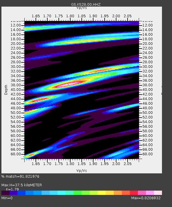
| Estimated Moho Depth: |
37.5 km |
| Estimated Crust Vp/Vs: |
1.79 |
| Assumed Crust Vp: |
6.483 km/s |
| Estimated Crust Vs: |
3.622 km/s |
| Estimated Crust Poisson's Ratio: |
0.27 |
|
| Radial Match: |
91.821976 % |
| Radial Bump: |
400 |
| Transverse Match: |
78.65498 % |
| Transverse Bump: |
400 |
| SOD ConfigId: |
25131211 |
| Insert Time: |
2021-10-08 12:05:27.221 +0000 |
| GWidth: |
2.5 |
| Max Bumps: |
400 |
| Tol: |
0.001 |
|

Signal To Noise
| Channel | StoN | STA | LTA |
| GS:KS28:00:HHZ:20210924T12:01:36.414001Z | 18.229858 | 2.5486586E-6 | 1.3980683E-7 |
| GS:KS28:00:HH1:20210924T12:01:36.414001Z | 3.7277913 | 8.115981E-7 | 2.1771554E-7 |
| GS:KS28:00:HH2:20210924T12:01:36.414001Z | 5.333255 | 1.0293996E-6 | 1.9301528E-7 |
| Arrivals |
| Ps | 4.8 SECOND |
| PpPs | 15 SECOND |
| PsPs/PpSs | 20 SECOND |


