You are here: Home > Network List > GS - US Geological Survey Networks Stations List
> Station OK038 West end E0370 Rd, Waynoka, OK, USA > Earthquake Result Viewer
OK038 West end E0370 Rd, Waynoka, OK, USA - Earthquake Result Viewer
| Earthquake location: |
Andreanof Islands, Aleutian Is. |
| Earthquake latitude/longitude: |
51.1/-178.9 |
| Earthquake time(UTC): |
2021/09/24 (267) 11:52:31 GMT |
| Earthquake Depth: |
50 km |
| Earthquake Magnitude: |
6.3 Mi |
| Earthquake Catalog/Contributor: |
NEIC PDE/at |
|
| Network: |
GS US Geological Survey Networks |
| Station: |
OK038 West end E0370 Rd, Waynoka, OK, USA |
| Lat/Lon: |
36.48 N/98.74 W |
| Elevation: |
443 m |
|
| Distance: |
56.9 deg |
| Az: |
71.404 deg |
| Baz: |
312.079 deg |
| Ray Param: |
0.06369575 |
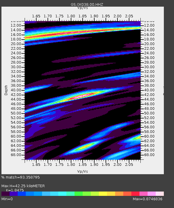
| Estimated Moho Depth: |
42.25 km |
| Estimated Crust Vp/Vs: |
1.85 |
| Assumed Crust Vp: |
6.426 km/s |
| Estimated Crust Vs: |
3.478 km/s |
| Estimated Crust Poisson's Ratio: |
0.29 |
|
| Radial Match: |
93.358795 % |
| Radial Bump: |
400 |
| Transverse Match: |
67.83913 % |
| Transverse Bump: |
400 |
| SOD ConfigId: |
25131211 |
| Insert Time: |
2021-10-08 12:05:30.597 +0000 |
| GWidth: |
2.5 |
| Max Bumps: |
400 |
| Tol: |
0.001 |
|

Signal To Noise
| Channel | StoN | STA | LTA |
| GS:OK038:00:HHZ:20210924T12:01:40.398987Z | 13.869276 | 2.543251E-6 | 1.8337302E-7 |
| GS:OK038:00:HH1:20210924T12:01:40.398987Z | 2.6332543 | 6.788666E-7 | 2.578052E-7 |
| GS:OK038:00:HH2:20210924T12:01:40.398987Z | 3.7350354 | 9.11639E-7 | 2.4407774E-7 |
| Arrivals |
| Ps | 5.8 SECOND |
| PpPs | 18 SECOND |
| PsPs/PpSs | 24 SECOND |


