You are here: Home > Network List > MB - Montana Regional Seismic Network Stations List
> Station BUT Butte, Montana > Earthquake Result Viewer
BUT Butte, Montana - Earthquake Result Viewer
| Earthquake location: |
Andreanof Islands, Aleutian Is. |
| Earthquake latitude/longitude: |
51.1/-178.9 |
| Earthquake time(UTC): |
2021/09/24 (267) 11:52:31 GMT |
| Earthquake Depth: |
50 km |
| Earthquake Magnitude: |
6.3 Mi |
| Earthquake Catalog/Contributor: |
NEIC PDE/at |
|
| Network: |
MB Montana Regional Seismic Network |
| Station: |
BUT Butte, Montana |
| Lat/Lon: |
46.01 N/112.56 W |
| Elevation: |
1758 m |
|
| Distance: |
42.9 deg |
| Az: |
69.709 deg |
| Baz: |
301.85 deg |
| Ray Param: |
0.0727564 |
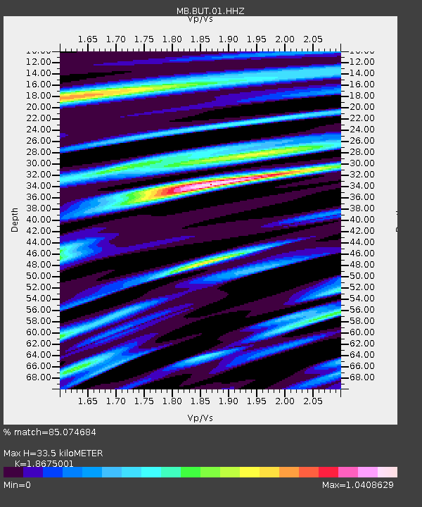
| Estimated Moho Depth: |
33.5 km |
| Estimated Crust Vp/Vs: |
1.87 |
| Assumed Crust Vp: |
6.353 km/s |
| Estimated Crust Vs: |
3.402 km/s |
| Estimated Crust Poisson's Ratio: |
0.30 |
|
| Radial Match: |
85.074684 % |
| Radial Bump: |
400 |
| Transverse Match: |
71.07828 % |
| Transverse Bump: |
400 |
| SOD ConfigId: |
25131211 |
| Insert Time: |
2021-10-08 12:09:16.138 +0000 |
| GWidth: |
2.5 |
| Max Bumps: |
400 |
| Tol: |
0.001 |
|

Signal To Noise
| Channel | StoN | STA | LTA |
| MB:BUT:01:HHZ:20210924T11:59:54.269989Z | 13.141336 | 3.854614E-6 | 2.933198E-7 |
| MB:BUT:01:HHN:20210924T11:59:54.269989Z | 5.5234127 | 1.3480541E-6 | 2.4406182E-7 |
| MB:BUT:01:HHE:20210924T11:59:54.269989Z | 4.5091763 | 1.5184861E-6 | 3.3675465E-7 |
| Arrivals |
| Ps | 4.9 SECOND |
| PpPs | 14 SECOND |
| PsPs/PpSs | 19 SECOND |


