You are here: Home > Network List > AK - Alaska Regional Network Stations List
> Station TRF Thorofare Mountian > Earthquake Result Viewer
TRF Thorofare Mountian - Earthquake Result Viewer
| Earthquake location: |
Solomon Islands |
| Earthquake latitude/longitude: |
-9.8/159.5 |
| Earthquake time(UTC): |
2007/08/16 (228) 08:39:27 GMT |
| Earthquake Depth: |
10 km |
| Earthquake Magnitude: |
6.1 MB, 6.7 MS, 6.4 MW |
| Earthquake Catalog/Contributor: |
WHDF/NEIC |
|
| Network: |
AK Alaska Regional Network |
| Station: |
TRF Thorofare Mountian |
| Lat/Lon: |
63.45 N/150.29 W |
| Elevation: |
1717 m |
|
| Distance: |
82.4 deg |
| Az: |
20.396 deg |
| Baz: |
229.846 deg |
| Ray Param: |
0.04689051 |
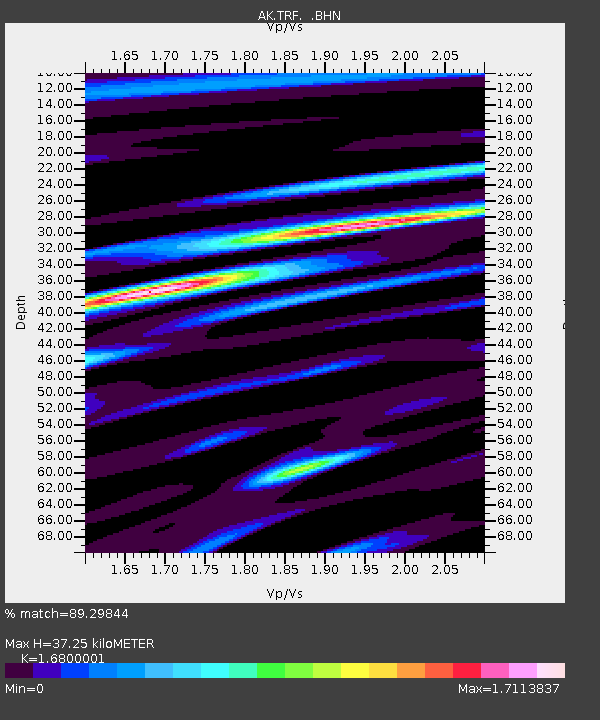
| Estimated Moho Depth: |
37.25 km |
| Estimated Crust Vp/Vs: |
1.68 |
| Assumed Crust Vp: |
6.438 km/s |
| Estimated Crust Vs: |
3.832 km/s |
| Estimated Crust Poisson's Ratio: |
0.23 |
|
| Radial Match: |
89.29844 % |
| Radial Bump: |
400 |
| Transverse Match: |
82.34552 % |
| Transverse Bump: |
400 |
| SOD ConfigId: |
2564 |
| Insert Time: |
2010-03-09 13:01:44.855 +0000 |
| GWidth: |
2.5 |
| Max Bumps: |
400 |
| Tol: |
0.001 |
|

Signal To Noise
| Channel | StoN | STA | LTA |
| AK:TRF: :BHN:20070816T08:51:18.51802Z | 5.291594 | 3.9155518E-7 | 7.399569E-8 |
| AK:TRF: :BHE:20070816T08:51:18.51802Z | 4.3592796 | 3.5484544E-7 | 8.1400024E-8 |
| AK:TRF: :BHZ:20070816T08:51:18.51802Z | 22.417936 | 1.1017182E-6 | 4.91445E-8 |
| Arrivals |
| Ps | 4.0 SECOND |
| PpPs | 15 SECOND |
| PsPs/PpSs | 19 SECOND |


