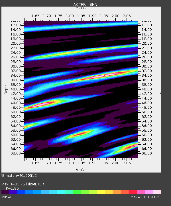
TRF Thorofare Mountian - Earthquake Result Viewer

Earthquake location: Near Coast Of Peru
Earthquake latitude/longitude: -13.4/-76.6
Earthquake time(UTC): 2007/08/15 (227) 23:40:57 GMT
Earthquake Depth: 39 km
Earthquake Magnitude: 6.7 MB, 7.9 MS, 8.0 MW, 7.5 ME
Earthquake Catalog/Contributor: WHDF/NEIC
Network: AK Alaska Regional Network
Station: TRF Thorofare Mountian
Lat/Lon: 63.45 N/150.29 W
Elevation: 1717 m
Distance: 94.7 deg
Az: 334.358 deg
Baz: 110.414 deg
Ray Param: 0.040948216
Estimated Moho Depth: 33.75 km
Estimated Crust Vp/Vs: 1.95
Assumed Crust Vp: 6.438 km/s
Estimated Crust Vs: 3.302 km/s
Estimated Crust Poisson's Ratio: 0.32
Radial Match: 91.50512 %
Radial Bump: 400
Transverse Match: 87.50625 %
Transverse Bump: 400
SOD ConfigId: 2564
Insert Time: 2010-03-09 13:01:46.128 +0000
GWidth: 2.5
Max Bumps: 400
Tol: 0.001

Signal To Noise

ChannelStoNSTALTA
AK:TRF: :BHN:20070815T23:53:43.840012Z5.036095.0355965E-79.99902E-8
AK:TRF: :BHE:20070815T23:53:43.840012Z6.0491385.4302194E-78.976848E-8
AK:TRF: :BHZ:20070815T23:53:43.840012Z19.7655871.8011655E-69.112634E-8
Arrivals
Ps5.1 SECOND
PpPs15 SECOND
PsPs/PpSs20 SECOND