You are here: Home > Network List > N4 - Central and EAstern US Network Stations List
> Station MDND Maddock, ND, USA > Earthquake Result Viewer
MDND Maddock, ND, USA - Earthquake Result Viewer
| Earthquake location: |
Andreanof Islands, Aleutian Is. |
| Earthquake latitude/longitude: |
51.1/-178.9 |
| Earthquake time(UTC): |
2021/09/24 (267) 11:52:31 GMT |
| Earthquake Depth: |
50 km |
| Earthquake Magnitude: |
6.3 Mi |
| Earthquake Catalog/Contributor: |
NEIC PDE/at |
|
| Network: |
N4 Central and EAstern US Network |
| Station: |
MDND Maddock, ND, USA |
| Lat/Lon: |
47.85 N/99.60 W |
| Elevation: |
479 m |
|
| Distance: |
49.3 deg |
| Az: |
60.805 deg |
| Baz: |
305.114 deg |
| Ray Param: |
0.06867195 |
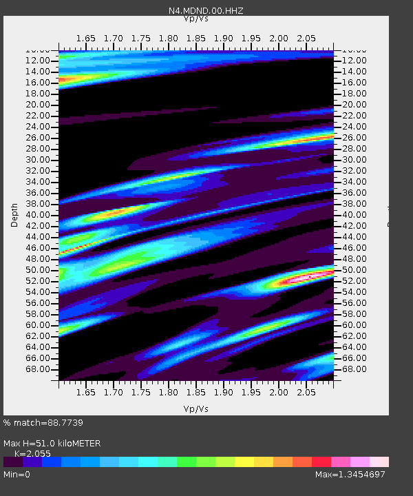
| Estimated Moho Depth: |
51.0 km |
| Estimated Crust Vp/Vs: |
2.06 |
| Assumed Crust Vp: |
6.53 km/s |
| Estimated Crust Vs: |
3.178 km/s |
| Estimated Crust Poisson's Ratio: |
0.34 |
|
| Radial Match: |
88.7739 % |
| Radial Bump: |
327 |
| Transverse Match: |
71.47225 % |
| Transverse Bump: |
328 |
| SOD ConfigId: |
25131211 |
| Insert Time: |
2021-10-08 12:11:03.617 +0000 |
| GWidth: |
2.5 |
| Max Bumps: |
400 |
| Tol: |
0.001 |
|

Signal To Noise
| Channel | StoN | STA | LTA |
| N4:MDND:00:HHZ:20210924T12:00:44.519989Z | 24.119314 | 2.8954864E-6 | 1.2004845E-7 |
| N4:MDND:00:HH1:20210924T12:00:44.519989Z | 3.5434477 | 1.076867E-6 | 3.0390373E-7 |
| N4:MDND:00:HH2:20210924T12:00:44.519989Z | 5.129807 | 1.8100727E-6 | 3.5285396E-7 |
| Arrivals |
| Ps | 8.7 SECOND |
| PpPs | 23 SECOND |
| PsPs/PpSs | 31 SECOND |


