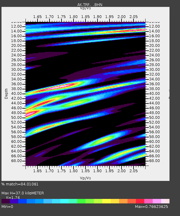
TRF Thorofare Mountian - Earthquake Result Viewer

Earthquake location: East Of Kuril Islands
Earthquake latitude/longitude: 46.2/154.4
Earthquake time(UTC): 2006/12/07 (341) 19:10:21 GMT
Earthquake Depth: 16 km
Earthquake Magnitude: 6.3 MB, 6.1 MS, 6.3 MW, 6.3 MW
Earthquake Catalog/Contributor: WHDF/NEIC
Network: AK Alaska Regional Network
Station: TRF Thorofare Mountian
Lat/Lon: 63.45 N/150.29 W
Elevation: 1717 m
Distance: 34.9 deg
Az: 40.205 deg
Baz: 266.971 deg
Ray Param: 0.07747593
Estimated Moho Depth: 37.0 km
Estimated Crust Vp/Vs: 1.74
Assumed Crust Vp: 6.438 km/s
Estimated Crust Vs: 3.7 km/s
Estimated Crust Poisson's Ratio: 0.25
Radial Match: 84.01061 %
Radial Bump: 400
Transverse Match: 77.714195 %
Transverse Bump: 400
SOD ConfigId: 2564
Insert Time: 2010-03-09 13:01:54.367 +0000
GWidth: 2.5
Max Bumps: 400
Tol: 0.001

Signal To Noise

ChannelStoNSTALTA
AK:TRF: :BHN:20061207T19:16:41.99801Z1.37580876.690127E-74.862687E-7
AK:TRF: :BHE:20061207T19:16:41.99801Z2.96103531.4827243E-65.007452E-7
AK:TRF: :BHZ:20061207T19:16:41.99801Z7.9240023.1582194E-63.9856369E-7
Arrivals
Ps4.6 SECOND
PpPs15 SECOND
PsPs/PpSs19 SECOND