You are here: Home > Network List > N4 - Central and EAstern US Network Stations List
> Station S51A Beattyville, KY, USA > Earthquake Result Viewer
S51A Beattyville, KY, USA - Earthquake Result Viewer
| Earthquake location: |
Andreanof Islands, Aleutian Is. |
| Earthquake latitude/longitude: |
51.1/-178.9 |
| Earthquake time(UTC): |
2021/09/24 (267) 11:52:31 GMT |
| Earthquake Depth: |
50 km |
| Earthquake Magnitude: |
6.3 Mi |
| Earthquake Catalog/Contributor: |
NEIC PDE/at |
|
| Network: |
N4 Central and EAstern US Network |
| Station: |
S51A Beattyville, KY, USA |
| Lat/Lon: |
37.64 N/83.59 W |
| Elevation: |
286 m |
|
| Distance: |
64.9 deg |
| Az: |
60.827 deg |
| Baz: |
316.035 deg |
| Ray Param: |
0.058555692 |
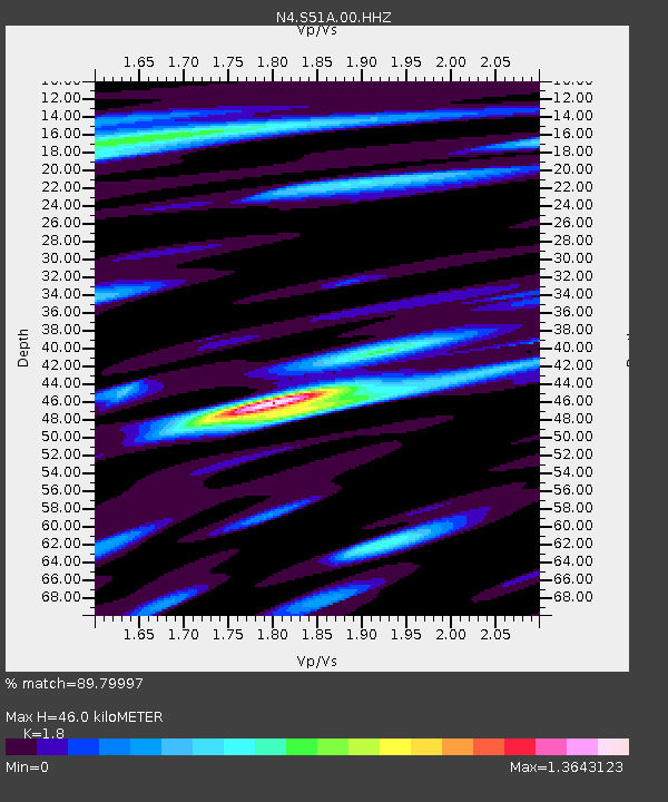
| Estimated Moho Depth: |
46.0 km |
| Estimated Crust Vp/Vs: |
1.80 |
| Assumed Crust Vp: |
6.476 km/s |
| Estimated Crust Vs: |
3.598 km/s |
| Estimated Crust Poisson's Ratio: |
0.28 |
|
| Radial Match: |
89.79997 % |
| Radial Bump: |
400 |
| Transverse Match: |
79.51752 % |
| Transverse Bump: |
400 |
| SOD ConfigId: |
25131211 |
| Insert Time: |
2021-10-08 12:11:48.660 +0000 |
| GWidth: |
2.5 |
| Max Bumps: |
400 |
| Tol: |
0.001 |
|

Signal To Noise
| Channel | StoN | STA | LTA |
| N4:S51A:00:HHZ:20210924T12:02:34.078979Z | 17.975302 | 3.0090077E-6 | 1.6739678E-7 |
| N4:S51A:00:HH1:20210924T12:02:34.078979Z | 5.184177 | 6.356908E-7 | 1.2262136E-7 |
| N4:S51A:00:HH2:20210924T12:02:34.078979Z | 5.9931884 | 7.51259E-7 | 1.2535214E-7 |
| Arrivals |
| Ps | 5.9 SECOND |
| PpPs | 19 SECOND |
| PsPs/PpSs | 25 SECOND |


