You are here: Home > Network List > N4 - Central and EAstern US Network Stations List
> Station TUL3 Leonard, OK, USA > Earthquake Result Viewer
TUL3 Leonard, OK, USA - Earthquake Result Viewer
| Earthquake location: |
Andreanof Islands, Aleutian Is. |
| Earthquake latitude/longitude: |
51.1/-178.9 |
| Earthquake time(UTC): |
2021/09/24 (267) 11:52:31 GMT |
| Earthquake Depth: |
50 km |
| Earthquake Magnitude: |
6.3 Mi |
| Earthquake Catalog/Contributor: |
NEIC PDE/at |
|
| Network: |
N4 Central and EAstern US Network |
| Station: |
TUL3 Leonard, OK, USA |
| Lat/Lon: |
35.91 N/95.79 W |
| Elevation: |
265 m |
|
| Distance: |
59.1 deg |
| Az: |
69.992 deg |
| Baz: |
313.066 deg |
| Ray Param: |
0.062322143 |
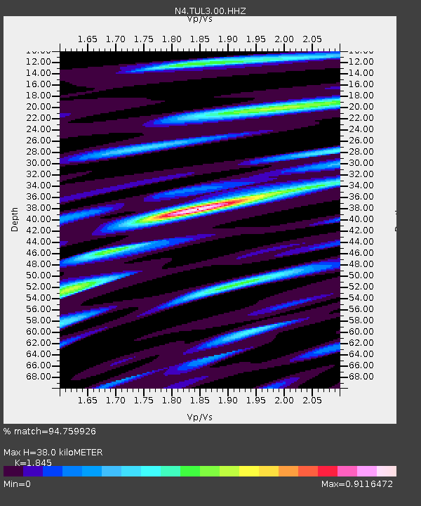
| Estimated Moho Depth: |
38.0 km |
| Estimated Crust Vp/Vs: |
1.85 |
| Assumed Crust Vp: |
6.498 km/s |
| Estimated Crust Vs: |
3.522 km/s |
| Estimated Crust Poisson's Ratio: |
0.29 |
|
| Radial Match: |
94.759926 % |
| Radial Bump: |
352 |
| Transverse Match: |
76.99526 % |
| Transverse Bump: |
400 |
| SOD ConfigId: |
25131211 |
| Insert Time: |
2021-10-08 12:12:00.357 +0000 |
| GWidth: |
2.5 |
| Max Bumps: |
400 |
| Tol: |
0.001 |
|

Signal To Noise
| Channel | StoN | STA | LTA |
| N4:TUL3:00:HHZ:20210924T12:01:55.348999Z | 18.014748 | 2.272182E-6 | 1.2612898E-7 |
| N4:TUL3:00:HH1:20210924T12:01:55.348999Z | 9.651345 | 8.6599664E-7 | 8.972807E-8 |
| N4:TUL3:00:HH2:20210924T12:01:55.348999Z | 8.048085 | 1.0227269E-6 | 1.2707706E-7 |
| Arrivals |
| Ps | 5.2 SECOND |
| PpPs | 16 SECOND |
| PsPs/PpSs | 21 SECOND |


