You are here: Home > Network List > NN - Western Great Basin/Eastern Sierra Nevada Stations List
> Station MCM05 Monte Cristo Menlo 05 > Earthquake Result Viewer
MCM05 Monte Cristo Menlo 05 - Earthquake Result Viewer
| Earthquake location: |
Andreanof Islands, Aleutian Is. |
| Earthquake latitude/longitude: |
51.1/-178.9 |
| Earthquake time(UTC): |
2021/09/24 (267) 11:52:31 GMT |
| Earthquake Depth: |
50 km |
| Earthquake Magnitude: |
6.3 Mi |
| Earthquake Catalog/Contributor: |
NEIC PDE/at |
|
| Network: |
NN Western Great Basin/Eastern Sierra Nevada |
| Station: |
MCM05 Monte Cristo Menlo 05 |
| Lat/Lon: |
38.16 N/117.87 W |
| Elevation: |
1591 m |
|
| Distance: |
44.1 deg |
| Az: |
82.36 deg |
| Baz: |
307.483 deg |
| Ray Param: |
0.07200048 |
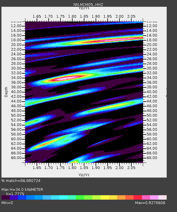
| Estimated Moho Depth: |
34.0 km |
| Estimated Crust Vp/Vs: |
1.78 |
| Assumed Crust Vp: |
6.276 km/s |
| Estimated Crust Vs: |
3.531 km/s |
| Estimated Crust Poisson's Ratio: |
0.27 |
|
| Radial Match: |
86.890724 % |
| Radial Bump: |
400 |
| Transverse Match: |
86.57497 % |
| Transverse Bump: |
400 |
| SOD ConfigId: |
25131211 |
| Insert Time: |
2021-10-08 12:13:32.076 +0000 |
| GWidth: |
2.5 |
| Max Bumps: |
400 |
| Tol: |
0.001 |
|

Signal To Noise
| Channel | StoN | STA | LTA |
| NN:MCM05: :HHZ:20210924T12:00:03.980011Z | 12.700378 | 1.3357126E-6 | 1.0517108E-7 |
| NN:MCM05: :HHN:20210924T12:00:03.980011Z | 4.791854 | 4.4747412E-7 | 9.3382255E-8 |
| NN:MCM05: :HHE:20210924T12:00:03.980011Z | 3.3920043 | 4.3598132E-7 | 1.2853206E-7 |
| Arrivals |
| Ps | 4.5 SECOND |
| PpPs | 14 SECOND |
| PsPs/PpSs | 19 SECOND |


