You are here: Home > Network List > NN - Western Great Basin/Eastern Sierra Nevada Stations List
> Station YER Yerington, Nevada w84gm > Earthquake Result Viewer
YER Yerington, Nevada w84gm - Earthquake Result Viewer
| Earthquake location: |
Andreanof Islands, Aleutian Is. |
| Earthquake latitude/longitude: |
51.1/-178.9 |
| Earthquake time(UTC): |
2021/09/24 (267) 11:52:31 GMT |
| Earthquake Depth: |
50 km |
| Earthquake Magnitude: |
6.3 Mi |
| Earthquake Catalog/Contributor: |
NEIC PDE/at |
|
| Network: |
NN Western Great Basin/Eastern Sierra Nevada |
| Station: |
YER Yerington, Nevada w84gm |
| Lat/Lon: |
38.99 N/119.24 W |
| Elevation: |
1857 m |
|
| Distance: |
42.8 deg |
| Az: |
82.34 deg |
| Baz: |
306.619 deg |
| Ray Param: |
0.07284741 |
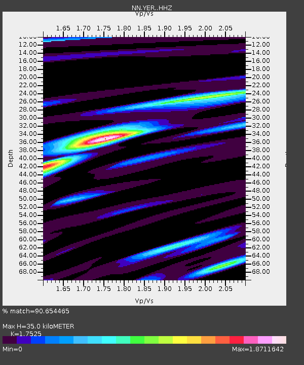
| Estimated Moho Depth: |
35.0 km |
| Estimated Crust Vp/Vs: |
1.75 |
| Assumed Crust Vp: |
6.279 km/s |
| Estimated Crust Vs: |
3.583 km/s |
| Estimated Crust Poisson's Ratio: |
0.26 |
|
| Radial Match: |
90.654465 % |
| Radial Bump: |
400 |
| Transverse Match: |
78.8562 % |
| Transverse Bump: |
400 |
| SOD ConfigId: |
25131211 |
| Insert Time: |
2021-10-08 12:14:03.497 +0000 |
| GWidth: |
2.5 |
| Max Bumps: |
400 |
| Tol: |
0.001 |
|

Signal To Noise
| Channel | StoN | STA | LTA |
| NN:YER: :HHZ:20210924T11:59:53.098999Z | 4.865106 | 1.134388E-6 | 2.3316818E-7 |
| NN:YER: :HHN:20210924T11:59:53.098999Z | 3.1030884 | 5.4624735E-7 | 1.7603345E-7 |
| NN:YER: :HHE:20210924T11:59:53.098999Z | 1.6965042 | 3.2883327E-7 | 1.938299E-7 |
| Arrivals |
| Ps | 4.5 SECOND |
| PpPs | 14 SECOND |
| PsPs/PpSs | 19 SECOND |


