You are here: Home > Network List > O2 - Oklahoma Consolidated Temporary Seismic Networks Stations List
> Station SC02 Maysville, Garvin & McClain Counties, OK, USA > Earthquake Result Viewer
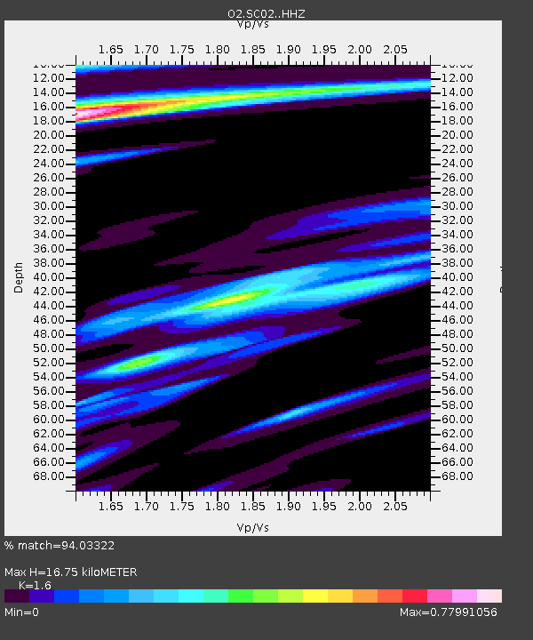
SC02 Maysville, Garvin & McClain Counties, OK, USA - Earthquake Result Viewer
| Earthquake location: |
Andreanof Islands, Aleutian Is. |
| Earthquake latitude/longitude: |
51.1/-178.9 |
| Earthquake time(UTC): |
2021/09/24 (267) 11:52:31 GMT |
| Earthquake Depth: |
50 km |
| Earthquake Magnitude: |
6.3 Mi |
| Earthquake Catalog/Contributor: |
NEIC PDE/at |
|
| Network: |
O2 Oklahoma Consolidated Temporary Seismic Networks |
| Station: |
SC02 Maysville, Garvin & McClain Counties, OK, USA |
| Lat/Lon: |
34.80 N/97.39 W |
| Elevation: |
310 m |
|
| Distance: |
58.9 deg |
| Az: |
71.98 deg |
| Baz: |
313.17 deg |
| Ray Param: |
0.062447794 |
| Estimated Moho Depth: |
16.75 km |
| Estimated Crust Vp/Vs: |
1.60 |
| Assumed Crust Vp: |
6.426 km/s |
| Estimated Crust Vs: |
4.016 km/s |
| Estimated Crust Poisson's Ratio: |
0.18 |
|
| Radial Match: |
94.03322 % |
| Radial Bump: |
304 |
| Transverse Match: |
83.59795 % |
| Transverse Bump: |
400 |
| SOD ConfigId: |
25131211 |
| Insert Time: |
2021-10-08 12:15:29.185 +0000 |
| GWidth: |
2.5 |
| Max Bumps: |
400 |
| Tol: |
0.001 |
|

Signal To Noise
| Channel | StoN | STA | LTA |
| O2:SC02: :HHZ:20210924T12:01:54.005005Z | 22.725653 | 2.9923483E-6 | 1.316727E-7 |
| O2:SC02: :HHN:20210924T12:01:54.005005Z | 4.521998 | 8.8756724E-7 | 1.9627768E-7 |
| O2:SC02: :HHE:20210924T12:01:54.005005Z | 3.4756124 | 8.3657295E-7 | 2.40698E-7 |
| Arrivals |
| Ps | 1.6 SECOND |
| PpPs | 6.4 SECOND |
| PsPs/PpSs | 8.1 SECOND |


