You are here: Home > Network List > O2 - Oklahoma Consolidated Temporary Seismic Networks Stations List
> Station SC03 Ninnekah, Oklahoma, USA > Earthquake Result Viewer
SC03 Ninnekah, Oklahoma, USA - Earthquake Result Viewer
| Earthquake location: |
Andreanof Islands, Aleutian Is. |
| Earthquake latitude/longitude: |
51.1/-178.9 |
| Earthquake time(UTC): |
2021/09/24 (267) 11:52:31 GMT |
| Earthquake Depth: |
50 km |
| Earthquake Magnitude: |
6.3 Mi |
| Earthquake Catalog/Contributor: |
NEIC PDE/at |
|
| Network: |
O2 Oklahoma Consolidated Temporary Seismic Networks |
| Station: |
SC03 Ninnekah, Oklahoma, USA |
| Lat/Lon: |
34.94 N/97.85 W |
| Elevation: |
349 m |
|
| Distance: |
58.5 deg |
| Az: |
72.16 deg |
| Baz: |
313.003 deg |
| Ray Param: |
0.06268135 |
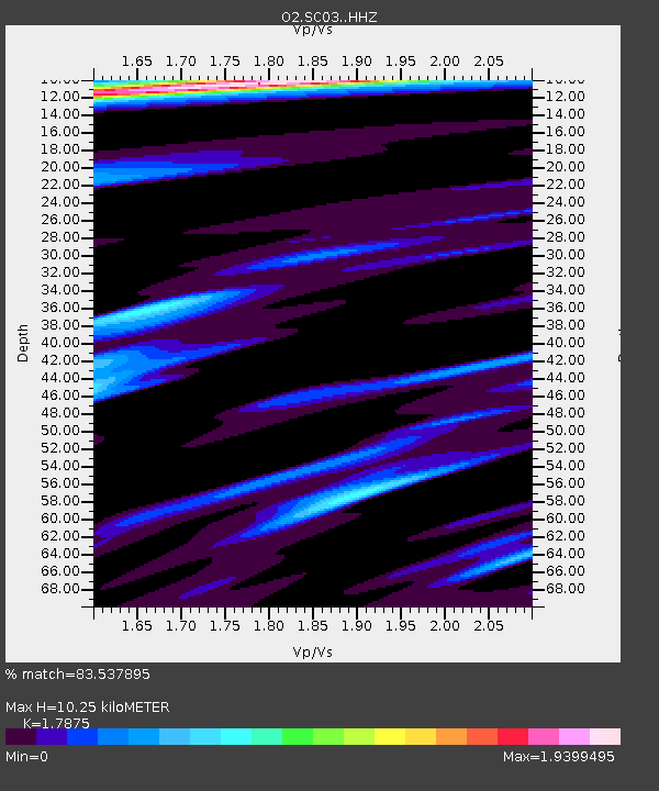
| Estimated Moho Depth: |
10.25 km |
| Estimated Crust Vp/Vs: |
1.79 |
| Assumed Crust Vp: |
6.426 km/s |
| Estimated Crust Vs: |
3.595 km/s |
| Estimated Crust Poisson's Ratio: |
0.27 |
|
| Radial Match: |
83.537895 % |
| Radial Bump: |
400 |
| Transverse Match: |
77.58711 % |
| Transverse Bump: |
400 |
| SOD ConfigId: |
25131211 |
| Insert Time: |
2021-10-08 12:15:29.759 +0000 |
| GWidth: |
2.5 |
| Max Bumps: |
400 |
| Tol: |
0.001 |
|

Signal To Noise
| Channel | StoN | STA | LTA |
| O2:SC03: :HHZ:20210924T12:01:51.414978Z | 10.041394 | 4.2580473E-6 | 4.2404938E-7 |
| O2:SC03: :HHN:20210924T12:01:51.414978Z | 1.9242914 | 7.4120766E-7 | 3.8518473E-7 |
| O2:SC03: :HHE:20210924T12:01:51.414978Z | 2.7630782 | 1.1930136E-6 | 4.3176973E-7 |
| Arrivals |
| Ps | 1.3 SECOND |
| PpPs | 4.2 SECOND |
| PsPs/PpSs | 5.6 SECOND |


