You are here: Home > Network List > O2 - Oklahoma Consolidated Temporary Seismic Networks Stations List
> Station SC13 Stratford, Oklahoma, USA > Earthquake Result Viewer
SC13 Stratford, Oklahoma, USA - Earthquake Result Viewer
| Earthquake location: |
Andreanof Islands, Aleutian Is. |
| Earthquake latitude/longitude: |
51.1/-178.9 |
| Earthquake time(UTC): |
2021/09/24 (267) 11:52:31 GMT |
| Earthquake Depth: |
50 km |
| Earthquake Magnitude: |
6.3 Mi |
| Earthquake Catalog/Contributor: |
NEIC PDE/at |
|
| Network: |
O2 Oklahoma Consolidated Temporary Seismic Networks |
| Station: |
SC13 Stratford, Oklahoma, USA |
| Lat/Lon: |
34.73 N/96.95 W |
| Elevation: |
363 m |
|
| Distance: |
59.2 deg |
| Az: |
71.747 deg |
| Baz: |
313.302 deg |
| Ray Param: |
0.06224266 |
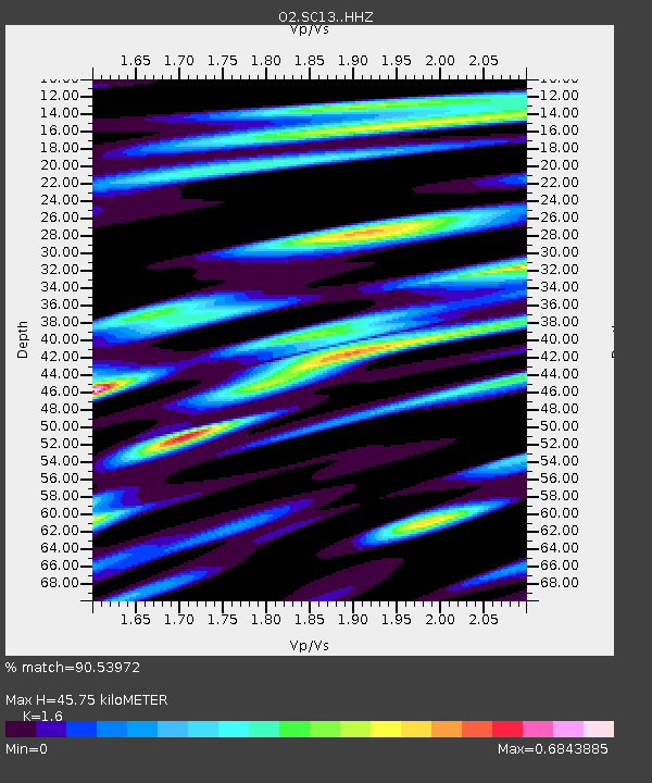
| Estimated Moho Depth: |
45.75 km |
| Estimated Crust Vp/Vs: |
1.60 |
| Assumed Crust Vp: |
6.426 km/s |
| Estimated Crust Vs: |
4.016 km/s |
| Estimated Crust Poisson's Ratio: |
0.18 |
|
| Radial Match: |
90.53972 % |
| Radial Bump: |
400 |
| Transverse Match: |
88.45058 % |
| Transverse Bump: |
400 |
| SOD ConfigId: |
25131211 |
| Insert Time: |
2021-10-08 12:15:41.596 +0000 |
| GWidth: |
2.5 |
| Max Bumps: |
400 |
| Tol: |
0.001 |
|

Signal To Noise
| Channel | StoN | STA | LTA |
| O2:SC13: :HHZ:20210924T12:01:56.174988Z | 21.410135 | 2.663282E-6 | 1.2439352E-7 |
| O2:SC13: :HHN:20210924T12:01:56.174988Z | 2.161649 | 3.1058332E-7 | 1.4367888E-7 |
| O2:SC13: :HHE:20210924T12:01:56.174988Z | 9.301239 | 1.4801358E-6 | 1.5913318E-7 |
| Arrivals |
| Ps | 4.5 SECOND |
| PpPs | 18 SECOND |
| PsPs/PpSs | 22 SECOND |


