You are here: Home > Network List > PE - Penn State Network Stations List
> Station PACH Chapman State Park, Clarendon, PA > Earthquake Result Viewer
PACH Chapman State Park, Clarendon, PA - Earthquake Result Viewer
| Earthquake location: |
Andreanof Islands, Aleutian Is. |
| Earthquake latitude/longitude: |
51.1/-178.9 |
| Earthquake time(UTC): |
2021/09/24 (267) 11:52:31 GMT |
| Earthquake Depth: |
50 km |
| Earthquake Magnitude: |
6.3 Mi |
| Earthquake Catalog/Contributor: |
NEIC PDE/at |
|
| Network: |
PE Penn State Network |
| Station: |
PACH Chapman State Park, Clarendon, PA |
| Lat/Lon: |
41.76 N/79.17 W |
| Elevation: |
431 m |
|
| Distance: |
64.2 deg |
| Az: |
54.949 deg |
| Baz: |
316.323 deg |
| Ray Param: |
0.05893677 |
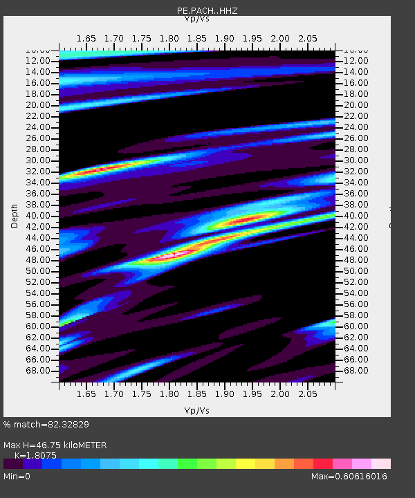
| Estimated Moho Depth: |
46.75 km |
| Estimated Crust Vp/Vs: |
1.81 |
| Assumed Crust Vp: |
6.121 km/s |
| Estimated Crust Vs: |
3.386 km/s |
| Estimated Crust Poisson's Ratio: |
0.28 |
|
| Radial Match: |
82.32829 % |
| Radial Bump: |
299 |
| Transverse Match: |
51.790886 % |
| Transverse Bump: |
400 |
| SOD ConfigId: |
25131211 |
| Insert Time: |
2021-10-08 12:17:23.846 +0000 |
| GWidth: |
2.5 |
| Max Bumps: |
400 |
| Tol: |
0.001 |
|

Signal To Noise
| Channel | StoN | STA | LTA |
| PE:PACH: :HHZ:20210924T12:02:30.155029Z | 11.344717 | 2.1630344E-6 | 1.9066445E-7 |
| PE:PACH: :HHN:20210924T12:02:30.155029Z | 5.5098233 | 8.140196E-7 | 1.477397E-7 |
| PE:PACH: :HHE:20210924T12:02:30.155029Z | 3.9084182 | 6.3229385E-7 | 1.6177742E-7 |
| Arrivals |
| Ps | 6.4 SECOND |
| PpPs | 21 SECOND |
| PsPs/PpSs | 27 SECOND |


