You are here: Home > Network List > PS - Pacific21 Stations List
> Station PSI Parapat, Indonesia > Earthquake Result Viewer
PSI Parapat, Indonesia - Earthquake Result Viewer
| Earthquake location: |
Andreanof Islands, Aleutian Is. |
| Earthquake latitude/longitude: |
51.1/-178.9 |
| Earthquake time(UTC): |
2021/09/24 (267) 11:52:31 GMT |
| Earthquake Depth: |
50 km |
| Earthquake Magnitude: |
6.3 Mi |
| Earthquake Catalog/Contributor: |
NEIC PDE/at |
|
| Network: |
PS Pacific21 |
| Station: |
PSI Parapat, Indonesia |
| Lat/Lon: |
2.69 N/98.92 E |
| Elevation: |
987 m |
|
| Distance: |
83.0 deg |
| Az: |
265.574 deg |
| Baz: |
39.048 deg |
| Ray Param: |
0.046439268 |
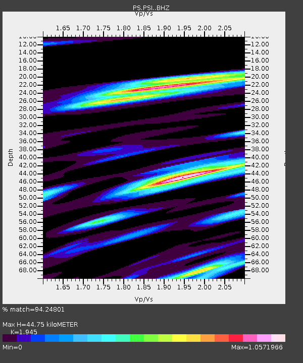
| Estimated Moho Depth: |
44.75 km |
| Estimated Crust Vp/Vs: |
1.95 |
| Assumed Crust Vp: |
6.468 km/s |
| Estimated Crust Vs: |
3.325 km/s |
| Estimated Crust Poisson's Ratio: |
0.32 |
|
| Radial Match: |
94.24801 % |
| Radial Bump: |
400 |
| Transverse Match: |
87.005035 % |
| Transverse Bump: |
383 |
| SOD ConfigId: |
25131211 |
| Insert Time: |
2021-10-08 12:19:03.364 +0000 |
| GWidth: |
2.5 |
| Max Bumps: |
400 |
| Tol: |
0.001 |
|
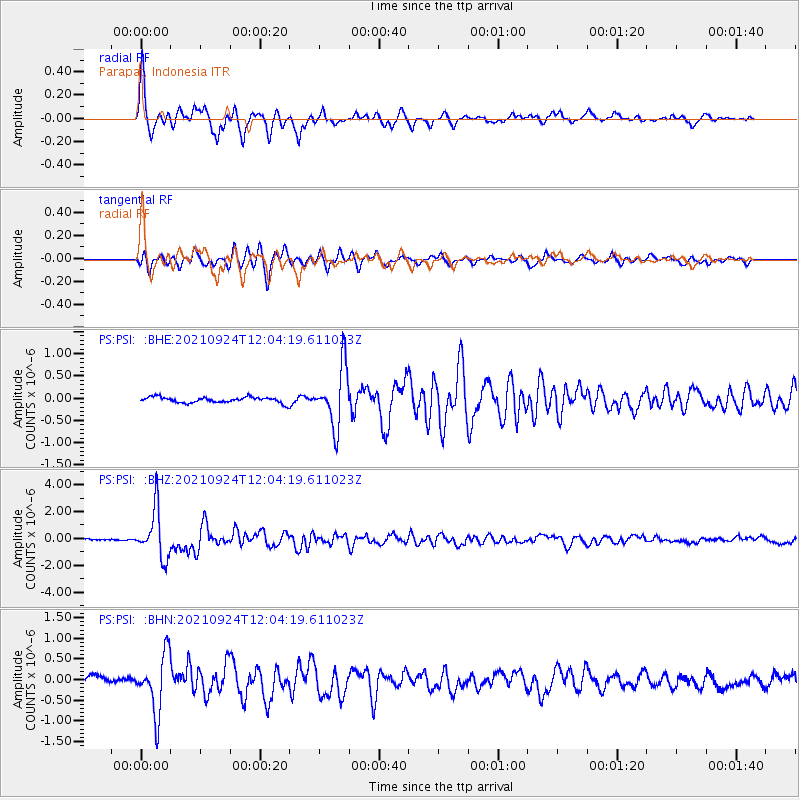
Signal To Noise
| Channel | StoN | STA | LTA |
| PS:PSI: :BHZ:20210924T12:04:19.611023Z | 26.875193 | 1.8107079E-6 | 6.737469E-8 |
| PS:PSI: :BHN:20210924T12:04:19.611023Z | 6.451659 | 7.0837325E-7 | 1.09797064E-7 |
| PS:PSI: :BHE:20210924T12:04:19.611023Z | 10.720882 | 6.709223E-7 | 6.258089E-8 |
| Arrivals |
| Ps | 6.7 SECOND |
| PpPs | 20 SECOND |
| PsPs/PpSs | 27 SECOND |


