You are here: Home > Network List > TX - Texas Seismological Network Stations List
> Station SMWD Samnorwood > Earthquake Result Viewer
SMWD Samnorwood - Earthquake Result Viewer
| Earthquake location: |
Andreanof Islands, Aleutian Is. |
| Earthquake latitude/longitude: |
51.1/-178.9 |
| Earthquake time(UTC): |
2021/09/24 (267) 11:52:31 GMT |
| Earthquake Depth: |
50 km |
| Earthquake Magnitude: |
6.3 Mi |
| Earthquake Catalog/Contributor: |
NEIC PDE/at |
|
| Network: |
TX Texas Seismological Network |
| Station: |
SMWD Samnorwood |
| Lat/Lon: |
35.10 N/100.24 W |
| Elevation: |
704 m |
|
| Distance: |
56.9 deg |
| Az: |
73.594 deg |
| Baz: |
312.4 deg |
| Ray Param: |
0.06368323 |
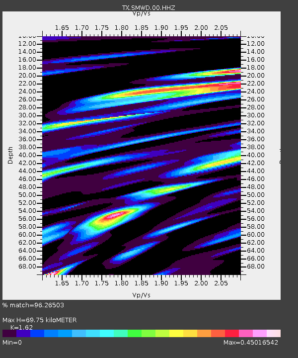
| Estimated Moho Depth: |
69.75 km |
| Estimated Crust Vp/Vs: |
1.62 |
| Assumed Crust Vp: |
6.426 km/s |
| Estimated Crust Vs: |
3.967 km/s |
| Estimated Crust Poisson's Ratio: |
0.19 |
|
| Radial Match: |
96.26503 % |
| Radial Bump: |
285 |
| Transverse Match: |
81.81113 % |
| Transverse Bump: |
400 |
| SOD ConfigId: |
25131211 |
| Insert Time: |
2021-10-08 12:22:39.227 +0000 |
| GWidth: |
2.5 |
| Max Bumps: |
400 |
| Tol: |
0.001 |
|

Signal To Noise
| Channel | StoN | STA | LTA |
| TX:SMWD:00:HHZ:20210924T12:01:40.525024Z | 17.86527 | 2.194328E-6 | 1.2282646E-7 |
| TX:SMWD:00:HH1:20210924T12:01:40.525024Z | 11.87419 | 1.1676906E-6 | 9.833854E-8 |
| TX:SMWD:00:HH2:20210924T12:01:40.525024Z | 4.081661 | 4.052019E-7 | 9.927377E-8 |
| Arrivals |
| Ps | 7.1 SECOND |
| PpPs | 27 SECOND |
| PsPs/PpSs | 34 SECOND |


