You are here: Home > Network List > US - United States National Seismic Network Stations List
> Station AMTX Amarillo, Texas, USA > Earthquake Result Viewer
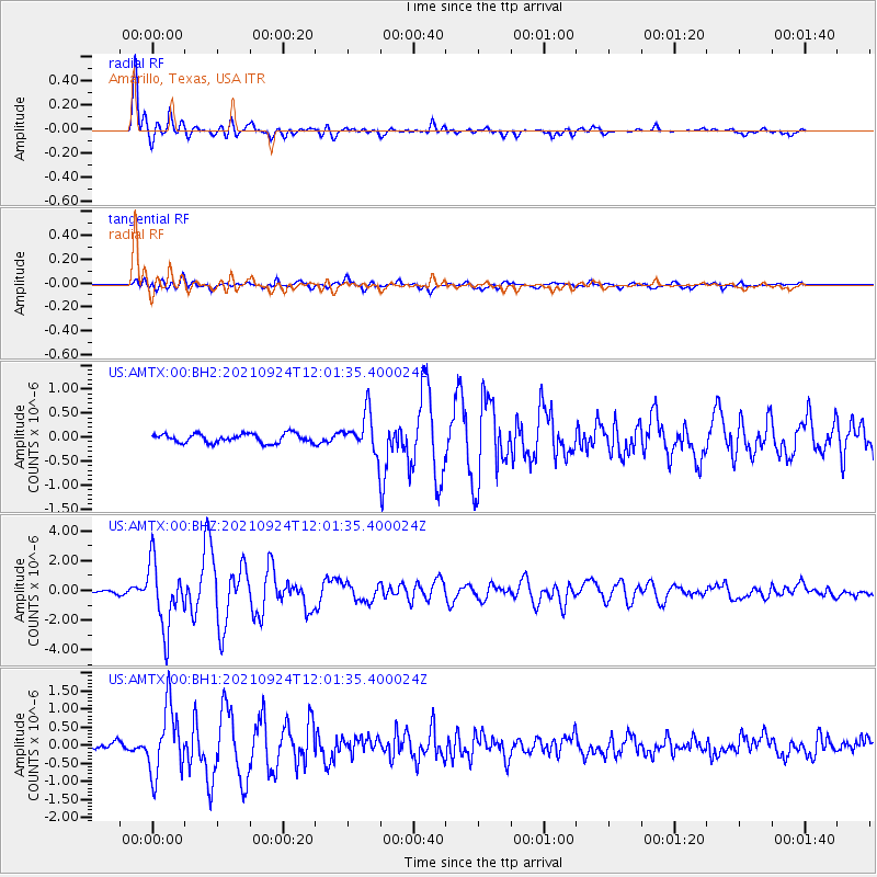
AMTX Amarillo, Texas, USA - Earthquake Result Viewer
*The percent match for this event was below the threshold and hence no stack was calculated.
| Earthquake location: |
Andreanof Islands, Aleutian Is. |
| Earthquake latitude/longitude: |
51.1/-178.9 |
| Earthquake time(UTC): |
2021/09/24 (267) 11:52:31 GMT |
| Earthquake Depth: |
50 km |
| Earthquake Magnitude: |
6.3 Mi |
| Earthquake Catalog/Contributor: |
NEIC PDE/at |
|
| Network: |
US United States National Seismic Network |
| Station: |
AMTX Amarillo, Texas, USA |
| Lat/Lon: |
34.53 N/101.41 W |
| Elevation: |
1010 m |
|
| Distance: |
56.6 deg |
| Az: |
74.873 deg |
| Baz: |
312.438 deg |
| Ray Param: |
$rayparam |
*The percent match for this event was below the threshold and hence was not used in the summary stack. |
|
| Radial Match: |
95.96165 % |
| Radial Bump: |
400 |
| Transverse Match: |
79.36415 % |
| Transverse Bump: |
400 |
| SOD ConfigId: |
25131211 |
| Insert Time: |
2021-10-08 12:24:07.954 +0000 |
| GWidth: |
2.5 |
| Max Bumps: |
400 |
| Tol: |
0.001 |
|
Signal To Noise
| Channel | StoN | STA | LTA |
| US:AMTX:00:BHZ:20210924T12:01:35.400024Z | 13.766864 | 2.1885164E-6 | 1.5896985E-7 |
| US:AMTX:00:BH1:20210924T12:01:35.400024Z | 11.105379 | 9.251969E-7 | 8.33107E-8 |
| US:AMTX:00:BH2:20210924T12:01:35.400024Z | 6.6306615 | 6.304672E-7 | 9.508361E-8 |
| Arrivals |
| Ps | |
| PpPs | |
| PsPs/PpSs | |


