You are here: Home > Network List > AK - Alaska Regional Network Stations List
> Station DCPH Deception Hills > Earthquake Result Viewer
DCPH Deception Hills - Earthquake Result Viewer
| Earthquake location: |
Fiji Islands Region |
| Earthquake latitude/longitude: |
-19.9/-178.2 |
| Earthquake time(UTC): |
2006/01/02 (002) 22:13:40 GMT |
| Earthquake Depth: |
583 km |
| Earthquake Magnitude: |
6.5 MB, 7.2 MW, 7.1 MW |
| Earthquake Catalog/Contributor: |
WHDF/NEIC |
|
| Network: |
AK Alaska Regional Network |
| Station: |
DCPH Deception Hills |
| Lat/Lon: |
59.09 N/138.21 W |
| Elevation: |
678 m |
|
| Distance: |
85.3 deg |
| Az: |
19.432 deg |
| Baz: |
217.328 deg |
| Ray Param: |
0.043184828 |
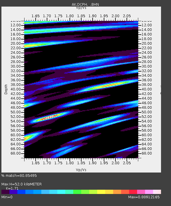
| Estimated Moho Depth: |
52.0 km |
| Estimated Crust Vp/Vs: |
1.71 |
| Assumed Crust Vp: |
6.183 km/s |
| Estimated Crust Vs: |
3.616 km/s |
| Estimated Crust Poisson's Ratio: |
0.24 |
|
| Radial Match: |
80.85495 % |
| Radial Bump: |
386 |
| Transverse Match: |
83.396545 % |
| Transverse Bump: |
400 |
| SOD ConfigId: |
2422 |
| Insert Time: |
2010-03-09 13:03:23.771 +0000 |
| GWidth: |
2.5 |
| Max Bumps: |
400 |
| Tol: |
0.001 |
|

Signal To Noise
| Channel | StoN | STA | LTA |
| AK:DCPH: :BHN:20060102T22:24:45.299021Z | 4.1516194 | 3.9151187E-6 | 9.430342E-7 |
| AK:DCPH: :BHE:20060102T22:24:45.299021Z | 5.3734837 | 3.773092E-6 | 7.021687E-7 |
| AK:DCPH: :BHZ:20060102T22:24:45.299021Z | 25.73318 | 1.8775047E-5 | 7.2960466E-7 |
| Arrivals |
| Ps | 6.1 SECOND |
| PpPs | 22 SECOND |
| PsPs/PpSs | 28 SECOND |


