You are here: Home > Network List > US - United States National Seismic Network Stations List
> Station MNTX Cornudas Mountains, Texas, USA > Earthquake Result Viewer
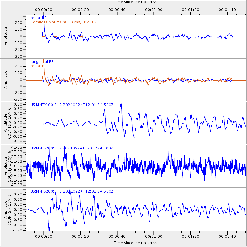
MNTX Cornudas Mountains, Texas, USA - Earthquake Result Viewer
*The percent match for this event was below the threshold and hence no stack was calculated.
| Earthquake location: |
Andreanof Islands, Aleutian Is. |
| Earthquake latitude/longitude: |
51.1/-178.9 |
| Earthquake time(UTC): |
2021/09/24 (267) 11:52:31 GMT |
| Earthquake Depth: |
50 km |
| Earthquake Magnitude: |
6.3 Mi |
| Earthquake Catalog/Contributor: |
NEIC PDE/at |
|
| Network: |
US United States National Seismic Network |
| Station: |
MNTX Cornudas Mountains, Texas, USA |
| Lat/Lon: |
31.70 N/105.38 W |
| Elevation: |
404 m |
|
| Distance: |
56.1 deg |
| Az: |
80.083 deg |
| Baz: |
313.164 deg |
| Ray Param: |
$rayparam |
*The percent match for this event was below the threshold and hence was not used in the summary stack. |
|
| Radial Match: |
73.995674 % |
| Radial Bump: |
382 |
| Transverse Match: |
78.7558 % |
| Transverse Bump: |
400 |
| SOD ConfigId: |
25131211 |
| Insert Time: |
2021-10-08 12:24:50.824 +0000 |
| GWidth: |
2.5 |
| Max Bumps: |
400 |
| Tol: |
0.001 |
|
Signal To Noise
| Channel | StoN | STA | LTA |
| US:MNTX:00:BHZ:20210924T12:01:34.500Z | 1.6723235 | 1.4092892E-9 | 8.427133E-10 |
| US:MNTX:00:BH1:20210924T12:01:34.500Z | 5.5653834 | 4.9847307E-7 | 8.956671E-8 |
| US:MNTX:00:BH2:20210924T12:01:34.500Z | 3.010543 | 2.5994618E-7 | 8.6345274E-8 |
| Arrivals |
| Ps | |
| PpPs | |
| PsPs/PpSs | |


