You are here: Home > Network List > US - United States National Seismic Network Stations List
> Station CBKS Cedar Bluff, Kansas, USA > Earthquake Result Viewer
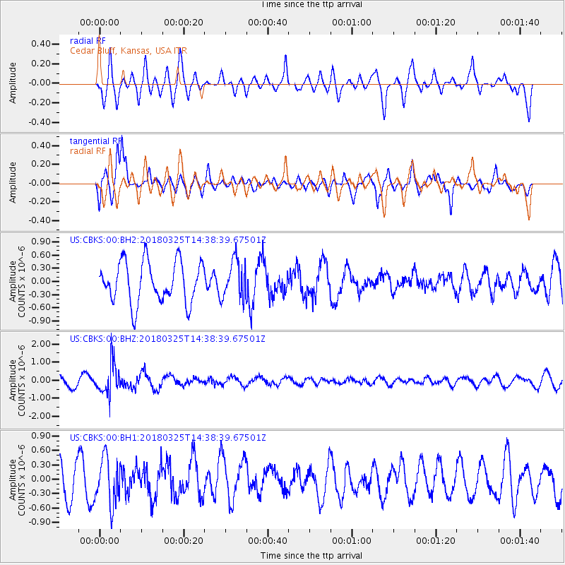
CBKS Cedar Bluff, Kansas, USA - Earthquake Result Viewer
*The percent match for this event was below the threshold and hence no stack was calculated.
| Earthquake location: |
Santiago Del Estero Prov., Arg. |
| Earthquake latitude/longitude: |
-26.8/-63.4 |
| Earthquake time(UTC): |
2018/03/25 (084) 14:28:34 GMT |
| Earthquake Depth: |
567 km |
| Earthquake Magnitude: |
5.6 Mww |
| Earthquake Catalog/Contributor: |
NEIC PDE/us |
|
| Network: |
US United States National Seismic Network |
| Station: |
CBKS Cedar Bluff, Kansas, USA |
| Lat/Lon: |
38.81 N/99.74 W |
| Elevation: |
677 m |
|
| Distance: |
73.6 deg |
| Az: |
331.115 deg |
| Baz: |
146.455 deg |
| Ray Param: |
$rayparam |
*The percent match for this event was below the threshold and hence was not used in the summary stack. |
|
| Radial Match: |
47.43379 % |
| Radial Bump: |
400 |
| Transverse Match: |
80.60787 % |
| Transverse Bump: |
400 |
| SOD ConfigId: |
2615551 |
| Insert Time: |
2018-04-08 14:38:36.468 +0000 |
| GWidth: |
2.5 |
| Max Bumps: |
400 |
| Tol: |
0.001 |
|
Signal To Noise
| Channel | StoN | STA | LTA |
| US:CBKS:00:BHZ:20180325T14:38:39.67501Z | 2.0805721 | 8.6873774E-7 | 4.1754754E-7 |
| US:CBKS:00:BH1:20180325T14:38:39.67501Z | 1.6591403 | 4.842917E-7 | 2.9189317E-7 |
| US:CBKS:00:BH2:20180325T14:38:39.67501Z | 0.9299039 | 4.3317053E-7 | 4.6582286E-7 |
| Arrivals |
| Ps | |
| PpPs | |
| PsPs/PpSs | |


