You are here: Home > Network List > UU - University of Utah Regional Network Stations List
> Station KNB Kanab, UT, USA > Earthquake Result Viewer
KNB Kanab, UT, USA - Earthquake Result Viewer
| Earthquake location: |
Andreanof Islands, Aleutian Is. |
| Earthquake latitude/longitude: |
51.1/-178.9 |
| Earthquake time(UTC): |
2021/09/24 (267) 11:52:31 GMT |
| Earthquake Depth: |
50 km |
| Earthquake Magnitude: |
6.3 Mi |
| Earthquake Catalog/Contributor: |
NEIC PDE/at |
|
| Network: |
UU University of Utah Regional Network |
| Station: |
KNB Kanab, UT, USA |
| Lat/Lon: |
37.02 N/112.82 W |
| Elevation: |
1715 m |
|
| Distance: |
48.0 deg |
| Az: |
80.151 deg |
| Baz: |
309.018 deg |
| Ray Param: |
0.06953759 |
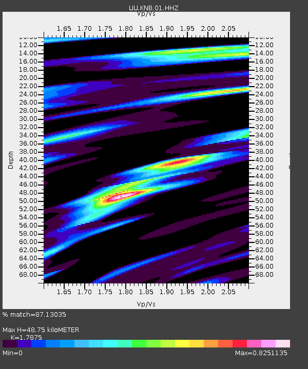
| Estimated Moho Depth: |
48.75 km |
| Estimated Crust Vp/Vs: |
1.79 |
| Assumed Crust Vp: |
6.194 km/s |
| Estimated Crust Vs: |
3.465 km/s |
| Estimated Crust Poisson's Ratio: |
0.27 |
|
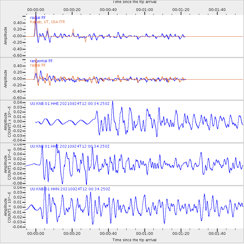
| Radial Match: |
87.13035 % |
| Radial Bump: |
364 |
| Transverse Match: |
87.462006 % |
| Transverse Bump: |
332 |
| SOD ConfigId: |
25131211 |
| Insert Time: |
2021-10-08 12:25:39.827 +0000 |
| GWidth: |
2.5 |
| Max Bumps: |
400 |
| Tol: |
0.001 |
|
Signal To Noise
| Channel | StoN | STA | LTA |
| UU:KNB:01:HHZ:20210924T12:00:34.250Z | 5.7541137 | 2.945022E-8 | 5.1181157E-9 |
| UU:KNB:01:HHN:20210924T12:00:34.250Z | 6.6002154 | 1.0325646E-8 | 1.5644407E-9 |
| UU:KNB:01:HHE:20210924T12:00:34.250Z | 2.7824638 | 9.880777E-9 | 3.551089E-9 |
| Arrivals |
| Ps | 6.6 SECOND |
| PpPs | 21 SECOND |
| PsPs/PpSs | 27 SECOND |


