You are here: Home > Network List > UU - University of Utah Regional Network Stations List
> Station MCU Monte Cristo, UT, USA > Earthquake Result Viewer
MCU Monte Cristo, UT, USA - Earthquake Result Viewer
| Earthquake location: |
Andreanof Islands, Aleutian Is. |
| Earthquake latitude/longitude: |
51.1/-178.9 |
| Earthquake time(UTC): |
2021/09/24 (267) 11:52:31 GMT |
| Earthquake Depth: |
50 km |
| Earthquake Magnitude: |
6.3 Mi |
| Earthquake Catalog/Contributor: |
NEIC PDE/at |
|
| Network: |
UU University of Utah Regional Network |
| Station: |
MCU Monte Cristo, UT, USA |
| Lat/Lon: |
41.46 N/111.51 W |
| Elevation: |
2668 m |
|
| Distance: |
46.1 deg |
| Az: |
74.489 deg |
| Baz: |
305.984 deg |
| Ray Param: |
0.07075449 |
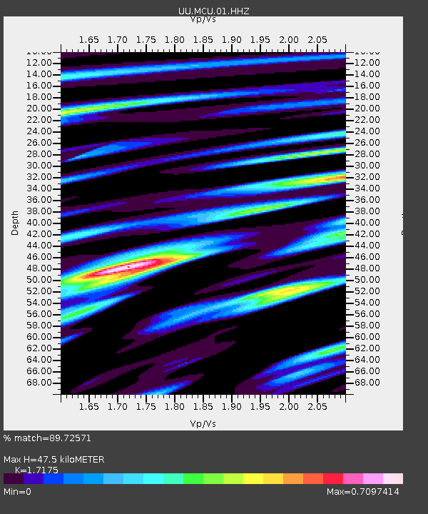
| Estimated Moho Depth: |
47.5 km |
| Estimated Crust Vp/Vs: |
1.72 |
| Assumed Crust Vp: |
6.155 km/s |
| Estimated Crust Vs: |
3.584 km/s |
| Estimated Crust Poisson's Ratio: |
0.24 |
|
| Radial Match: |
89.72571 % |
| Radial Bump: |
375 |
| Transverse Match: |
73.62767 % |
| Transverse Bump: |
400 |
| SOD ConfigId: |
25131211 |
| Insert Time: |
2021-10-08 12:26:07.428 +0000 |
| GWidth: |
2.5 |
| Max Bumps: |
400 |
| Tol: |
0.001 |
|

Signal To Noise
| Channel | StoN | STA | LTA |
| UU:MCU:01:HHZ:20210924T12:00:19.51001Z | 15.986102 | 1.6448081E-6 | 1.0288988E-7 |
| UU:MCU:01:HHN:20210924T12:00:19.51001Z | 5.6202064 | 4.7506694E-7 | 8.452839E-8 |
| UU:MCU:01:HHE:20210924T12:00:19.51001Z | 5.18454 | 6.2324256E-7 | 1.2021174E-7 |
| Arrivals |
| Ps | 5.9 SECOND |
| PpPs | 20 SECOND |
| PsPs/PpSs | 26 SECOND |


