You are here: Home > Network List > UW - Pacific Northwest Regional Seismic Network Stations List
> Station DAVN Davenport, WA, USA > Earthquake Result Viewer
DAVN Davenport, WA, USA - Earthquake Result Viewer
| Earthquake location: |
Andreanof Islands, Aleutian Is. |
| Earthquake latitude/longitude: |
51.1/-178.9 |
| Earthquake time(UTC): |
2021/09/24 (267) 11:52:31 GMT |
| Earthquake Depth: |
50 km |
| Earthquake Magnitude: |
6.3 Mi |
| Earthquake Catalog/Contributor: |
NEIC PDE/at |
|
| Network: |
UW Pacific Northwest Regional Seismic Network |
| Station: |
DAVN Davenport, WA, USA |
| Lat/Lon: |
47.80 N/118.27 W |
| Elevation: |
483 m |
|
| Distance: |
38.6 deg |
| Az: |
70.339 deg |
| Baz: |
298.163 deg |
| Ray Param: |
0.07535423 |
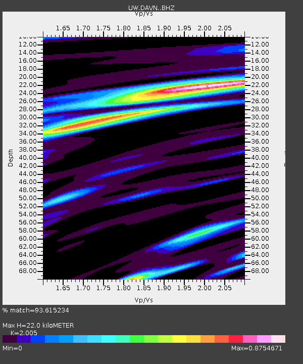
| Estimated Moho Depth: |
22.0 km |
| Estimated Crust Vp/Vs: |
2.01 |
| Assumed Crust Vp: |
6.419 km/s |
| Estimated Crust Vs: |
3.202 km/s |
| Estimated Crust Poisson's Ratio: |
0.33 |
|
| Radial Match: |
93.615234 % |
| Radial Bump: |
383 |
| Transverse Match: |
76.21237 % |
| Transverse Bump: |
400 |
| SOD ConfigId: |
25131211 |
| Insert Time: |
2021-10-08 12:26:30.411 +0000 |
| GWidth: |
2.5 |
| Max Bumps: |
400 |
| Tol: |
0.001 |
|
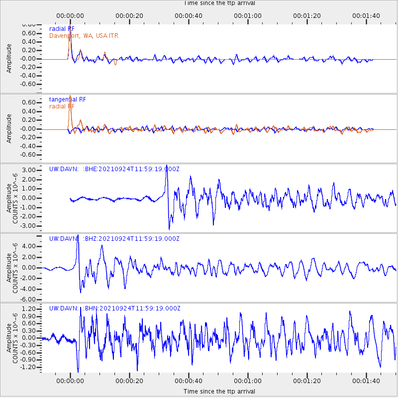
Signal To Noise
| Channel | StoN | STA | LTA |
| UW:DAVN: :BHZ:20210924T11:59:19.000Z | 26.501137 | 2.7009053E-6 | 1.0191658E-7 |
| UW:DAVN: :BHN:20210924T11:59:19.000Z | 7.8669224 | 5.8851094E-7 | 7.4808284E-8 |
| UW:DAVN: :BHE:20210924T11:59:19.000Z | 15.173014 | 1.7083546E-6 | 1.1259164E-7 |
| Arrivals |
| Ps | 3.7 SECOND |
| PpPs | 9.7 SECOND |
| PsPs/PpSs | 13 SECOND |


