You are here: Home > Network List > UW - Pacific Northwest Regional Seismic Network Stations List
> Station UMAT Pilot Rock, OR, USA > Earthquake Result Viewer
UMAT Pilot Rock, OR, USA - Earthquake Result Viewer
| Earthquake location: |
Andreanof Islands, Aleutian Is. |
| Earthquake latitude/longitude: |
51.1/-178.9 |
| Earthquake time(UTC): |
2021/09/24 (267) 11:52:31 GMT |
| Earthquake Depth: |
50 km |
| Earthquake Magnitude: |
6.3 Mi |
| Earthquake Catalog/Contributor: |
NEIC PDE/at |
|
| Network: |
UW Pacific Northwest Regional Seismic Network |
| Station: |
UMAT Pilot Rock, OR, USA |
| Lat/Lon: |
45.29 N/118.96 W |
| Elevation: |
1318 m |
|
| Distance: |
39.4 deg |
| Az: |
74.181 deg |
| Baz: |
300.653 deg |
| Ray Param: |
0.074853666 |
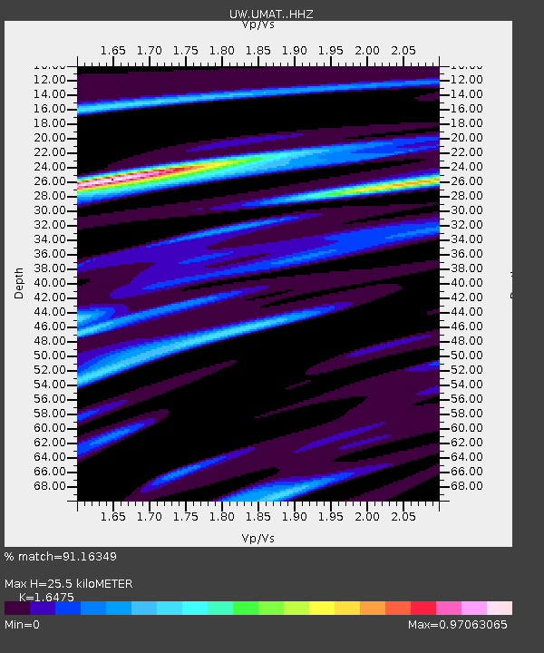
| Estimated Moho Depth: |
25.5 km |
| Estimated Crust Vp/Vs: |
1.65 |
| Assumed Crust Vp: |
6.571 km/s |
| Estimated Crust Vs: |
3.988 km/s |
| Estimated Crust Poisson's Ratio: |
0.21 |
|
| Radial Match: |
91.16349 % |
| Radial Bump: |
323 |
| Transverse Match: |
78.71627 % |
| Transverse Bump: |
400 |
| SOD ConfigId: |
25131211 |
| Insert Time: |
2021-10-08 12:28:06.428 +0000 |
| GWidth: |
2.5 |
| Max Bumps: |
400 |
| Tol: |
0.001 |
|

Signal To Noise
| Channel | StoN | STA | LTA |
| UW:UMAT: :HHZ:20210924T11:59:25.850006Z | 10.705392 | 1.6027127E-6 | 1.4971079E-7 |
| UW:UMAT: :HHN:20210924T11:59:25.850006Z | 5.1153016 | 4.771592E-7 | 9.328075E-8 |
| UW:UMAT: :HHE:20210924T11:59:25.850006Z | 9.233594 | 9.902511E-7 | 1.0724438E-7 |
| Arrivals |
| Ps | 2.7 SECOND |
| PpPs | 9.5 SECOND |
| PsPs/PpSs | 12 SECOND |


