You are here: Home > Network List > WU - The Southern Ontario Seismic Network Stations List
> Station PEMO Pembroke, Ontario, Canada > Earthquake Result Viewer
PEMO Pembroke, Ontario, Canada - Earthquake Result Viewer
| Earthquake location: |
Andreanof Islands, Aleutian Is. |
| Earthquake latitude/longitude: |
51.1/-178.9 |
| Earthquake time(UTC): |
2021/09/24 (267) 11:52:31 GMT |
| Earthquake Depth: |
50 km |
| Earthquake Magnitude: |
6.3 Mi |
| Earthquake Catalog/Contributor: |
NEIC PDE/at |
|
| Network: |
WU The Southern Ontario Seismic Network |
| Station: |
PEMO Pembroke, Ontario, Canada |
| Lat/Lon: |
45.68 N/77.25 W |
| Elevation: |
180 m |
|
| Distance: |
62.4 deg |
| Az: |
50.78 deg |
| Baz: |
315.777 deg |
| Ray Param: |
0.060144994 |
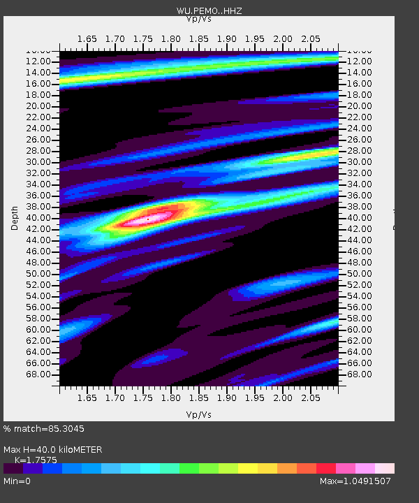
| Estimated Moho Depth: |
40.0 km |
| Estimated Crust Vp/Vs: |
1.76 |
| Assumed Crust Vp: |
6.577 km/s |
| Estimated Crust Vs: |
3.742 km/s |
| Estimated Crust Poisson's Ratio: |
0.26 |
|
| Radial Match: |
85.3045 % |
| Radial Bump: |
353 |
| Transverse Match: |
55.264935 % |
| Transverse Bump: |
400 |
| SOD ConfigId: |
25131211 |
| Insert Time: |
2021-10-08 12:29:30.146 +0000 |
| GWidth: |
2.5 |
| Max Bumps: |
400 |
| Tol: |
0.001 |
|

Signal To Noise
| Channel | StoN | STA | LTA |
| WU:PEMO: :HHZ:20210924T12:02:17.919983Z | 7.738979 | 7.3623073E-7 | 9.51328E-8 |
| WU:PEMO: :HHN:20210924T12:02:17.919983Z | 2.8779979 | 2.0535246E-7 | 7.135254E-8 |
| WU:PEMO: :HHE:20210924T12:02:17.919983Z | 3.4039066 | 2.6730126E-7 | 7.85278E-8 |
| Arrivals |
| Ps | 4.8 SECOND |
| PpPs | 16 SECOND |
| PsPs/PpSs | 21 SECOND |


