You are here: Home > Network List > AK - Alaska Regional Network Stations List
> Station MCK McKinley Park > Earthquake Result Viewer
MCK McKinley Park - Earthquake Result Viewer
| Earthquake location: |
Southern India |
| Earthquake latitude/longitude: |
23.4/70.2 |
| Earthquake time(UTC): |
2001/01/26 (026) 03:16:40 GMT |
| Earthquake Depth: |
16 km |
| Earthquake Magnitude: |
6.9 MB, 8.0 MS, 7.7 MW, 7.7 ME |
| Earthquake Catalog/Contributor: |
WHDF/NEIC |
|
| Network: |
AK Alaska Regional Network |
| Station: |
MCK McKinley Park |
| Lat/Lon: |
63.73 N/148.93 W |
| Elevation: |
618 m |
|
| Distance: |
87.9 deg |
| Az: |
16.333 deg |
| Baz: |
324.51 deg |
| Ray Param: |
0.04299272 |
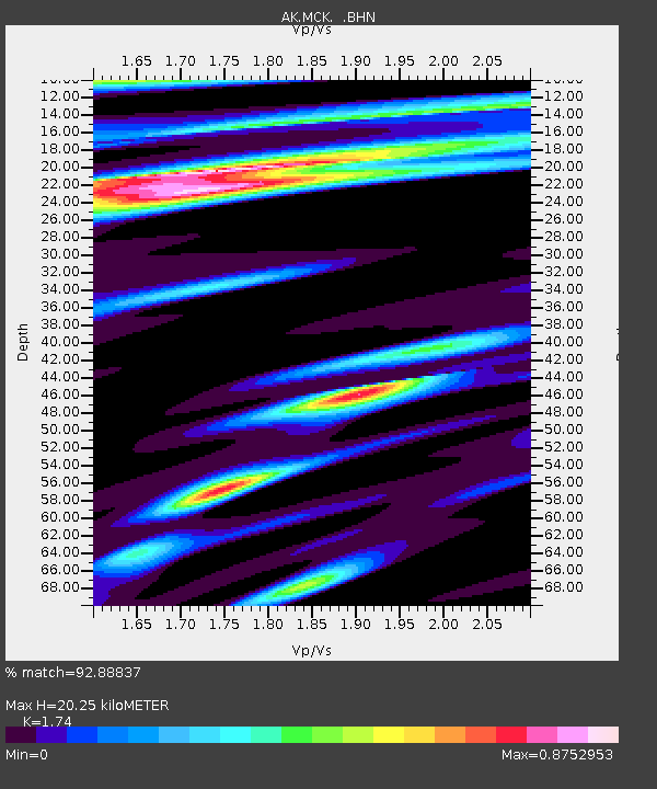
| Estimated Moho Depth: |
20.25 km |
| Estimated Crust Vp/Vs: |
1.74 |
| Assumed Crust Vp: |
6.566 km/s |
| Estimated Crust Vs: |
3.774 km/s |
| Estimated Crust Poisson's Ratio: |
0.25 |
|
| Radial Match: |
92.88837 % |
| Radial Bump: |
400 |
| Transverse Match: |
81.64317 % |
| Transverse Bump: |
400 |
| SOD ConfigId: |
263228 |
| Insert Time: |
2010-03-09 13:04:26.906 +0000 |
| GWidth: |
2.5 |
| Max Bumps: |
400 |
| Tol: |
0.001 |
|

Signal To Noise
| Channel | StoN | STA | LTA |
| AK:MCK: :BHN:20010126T03:28:57.580017Z | 3.44857 | 1.6988783E-6 | 4.926327E-7 |
| AK:MCK: :BHE:20010126T03:28:57.580017Z | 1.252326 | 4.930551E-7 | 3.9371147E-7 |
| AK:MCK: :BHZ:20010126T03:28:57.580017Z | 20.075172 | 6.9899706E-6 | 3.4818984E-7 |
| Arrivals |
| Ps | 2.3 SECOND |
| PpPs | 8.3 SECOND |
| PsPs/PpSs | 11 SECOND |


