You are here: Home > Network List > AK - Alaska Regional Network Stations List
> Station H21K Melozitna River, AK, USA > Earthquake Result Viewer
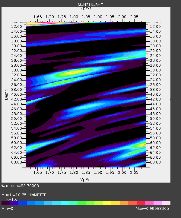
H21K Melozitna River, AK, USA - Earthquake Result Viewer
| Earthquake location: |
Crete, Greece |
| Earthquake latitude/longitude: |
35.3/25.3 |
| Earthquake time(UTC): |
2021/09/27 (270) 06:17:22 GMT |
| Earthquake Depth: |
8.7 km |
| Earthquake Magnitude: |
6.0 mww |
| Earthquake Catalog/Contributor: |
NEIC PDE/us |
|
| Network: |
AK Alaska Regional Network |
| Station: |
H21K Melozitna River, AK, USA |
| Lat/Lon: |
65.66 N/152.80 W |
| Elevation: |
520 m |
|
| Distance: |
79.4 deg |
| Az: |
359.184 deg |
| Baz: |
1.611 deg |
| Ray Param: |
0.048991255 |
| Estimated Moho Depth: |
10.75 km |
| Estimated Crust Vp/Vs: |
1.60 |
| Assumed Crust Vp: |
6.566 km/s |
| Estimated Crust Vs: |
4.104 km/s |
| Estimated Crust Poisson's Ratio: |
0.18 |
|
| Radial Match: |
83.70003 % |
| Radial Bump: |
325 |
| Transverse Match: |
76.68367 % |
| Transverse Bump: |
400 |
| SOD ConfigId: |
25131211 |
| Insert Time: |
2021-10-11 06:20:12.161 +0000 |
| GWidth: |
2.5 |
| Max Bumps: |
400 |
| Tol: |
0.001 |
|

Signal To Noise
| Channel | StoN | STA | LTA |
| AK:H21K: :BHZ:20210927T06:28:57.339996Z | 14.882253 | 1.4948236E-6 | 1.00443366E-7 |
| AK:H21K: :BHN:20210927T06:28:57.339996Z | 6.107536 | 5.974888E-7 | 9.782812E-8 |
| AK:H21K: :BHE:20210927T06:28:57.339996Z | 1.7553768 | 1.5725928E-7 | 8.958719E-8 |
| Arrivals |
| Ps | 1.0 SECOND |
| PpPs | 4.1 SECOND |
| PsPs/PpSs | 5.1 SECOND |


