You are here: Home > Network List > AV - Alaska Volcano Observatory Stations List
> Station MAPS Pakushin Southeast, Makushin Volcano, Alaska > Earthquake Result Viewer
MAPS Pakushin Southeast, Makushin Volcano, Alaska - Earthquake Result Viewer
| Earthquake location: |
Crete, Greece |
| Earthquake latitude/longitude: |
35.3/25.3 |
| Earthquake time(UTC): |
2021/09/27 (270) 06:17:22 GMT |
| Earthquake Depth: |
8.7 km |
| Earthquake Magnitude: |
6.0 mww |
| Earthquake Catalog/Contributor: |
NEIC PDE/us |
|
| Network: |
AV Alaska Volcano Observatory |
| Station: |
MAPS Pakushin Southeast, Makushin Volcano, Alaska |
| Lat/Lon: |
53.81 N/166.94 W |
| Elevation: |
333 m |
|
| Distance: |
90.7 deg |
| Az: |
7.2 deg |
| Baz: |
350.039 deg |
| Ray Param: |
0.041686527 |
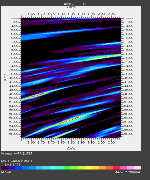
| Estimated Moho Depth: |
60.5 km |
| Estimated Crust Vp/Vs: |
1.85 |
| Assumed Crust Vp: |
3.943 km/s |
| Estimated Crust Vs: |
2.134 km/s |
| Estimated Crust Poisson's Ratio: |
0.29 |
|
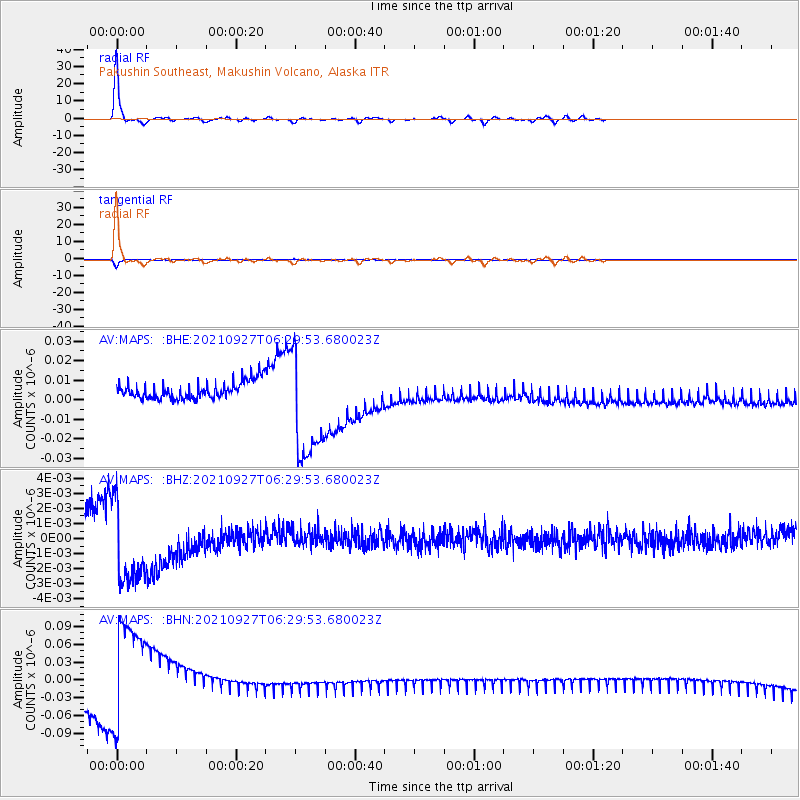
| Radial Match: |
97.21424 % |
| Radial Bump: |
211 |
| Transverse Match: |
95.38012 % |
| Transverse Bump: |
280 |
| SOD ConfigId: |
25131211 |
| Insert Time: |
2021-10-11 06:23:50.520 +0000 |
| GWidth: |
2.5 |
| Max Bumps: |
400 |
| Tol: |
0.001 |
|
Signal To Noise
| Channel | StoN | STA | LTA |
| AV:MAPS: :BHZ:20210927T06:29:53.680023Z | 4.570061 | 2.890423E-9 | 6.324692E-10 |
| AV:MAPS: :BHN:20210927T06:29:53.680023Z | 6.6307 | 9.420722E-8 | 1.4207734E-8 |
| AV:MAPS: :BHE:20210927T06:29:53.680023Z | 6.667337 | 2.8880674E-8 | 4.3316657E-9 |
| Arrivals |
| Ps | 13 SECOND |
| PpPs | 43 SECOND |
| PsPs/PpSs | 56 SECOND |


