You are here: Home > Network List > US - United States National Seismic Network Stations List
> Station AMTX Amarillo, Texas, USA > Earthquake Result Viewer
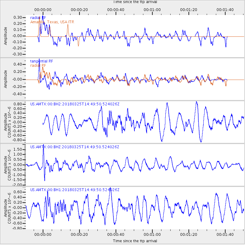
AMTX Amarillo, Texas, USA - Earthquake Result Viewer
*The percent match for this event was below the threshold and hence no stack was calculated.
| Earthquake location: |
Southeast Of Honshu, Japan |
| Earthquake latitude/longitude: |
32.6/140.6 |
| Earthquake time(UTC): |
2018/03/25 (084) 14:37:23 GMT |
| Earthquake Depth: |
51 km |
| Earthquake Magnitude: |
5.7 Mww |
| Earthquake Catalog/Contributor: |
NEIC PDE/us |
|
| Network: |
US United States National Seismic Network |
| Station: |
AMTX Amarillo, Texas, USA |
| Lat/Lon: |
34.53 N/101.41 W |
| Elevation: |
1010 m |
|
| Distance: |
91.4 deg |
| Az: |
46.848 deg |
| Baz: |
311.765 deg |
| Ray Param: |
$rayparam |
*The percent match for this event was below the threshold and hence was not used in the summary stack. |
|
| Radial Match: |
57.05619 % |
| Radial Bump: |
400 |
| Transverse Match: |
62.18578 % |
| Transverse Bump: |
400 |
| SOD ConfigId: |
2615551 |
| Insert Time: |
2018-04-08 14:44:39.922 +0000 |
| GWidth: |
2.5 |
| Max Bumps: |
400 |
| Tol: |
0.001 |
|
Signal To Noise
| Channel | StoN | STA | LTA |
| US:AMTX:00:BHZ:20180325T14:49:50.524026Z | 2.5971568 | 6.835884E-7 | 2.6320643E-7 |
| US:AMTX:00:BH1:20180325T14:49:50.524026Z | 1.5451816 | 3.4268643E-7 | 2.2177746E-7 |
| US:AMTX:00:BH2:20180325T14:49:50.524026Z | 1.6770756 | 4.2306613E-7 | 2.522642E-7 |
| Arrivals |
| Ps | |
| PpPs | |
| PsPs/PpSs | |


