You are here: Home > Network List > AK - Alaska Regional Network Stations List
> Station MCK McKinley Park > Earthquake Result Viewer
MCK McKinley Park - Earthquake Result Viewer
| Earthquake location: |
Fiji Islands Region |
| Earthquake latitude/longitude: |
-17.6/-178.6 |
| Earthquake time(UTC): |
2004/07/15 (197) 04:27:12 GMT |
| Earthquake Depth: |
560 km |
| Earthquake Magnitude: |
5.5 MB |
| Earthquake Catalog/Contributor: |
WHDF/NEIC |
|
| Network: |
AK Alaska Regional Network |
| Station: |
MCK McKinley Park |
| Lat/Lon: |
63.73 N/148.93 W |
| Elevation: |
618 m |
|
| Distance: |
84.3 deg |
| Az: |
12.793 deg |
| Baz: |
208.33 deg |
| Ray Param: |
0.043939933 |
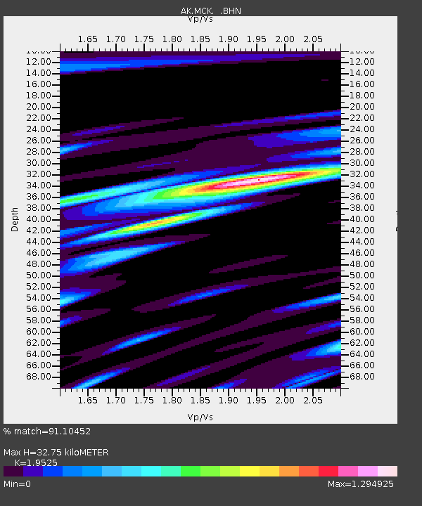
| Estimated Moho Depth: |
32.75 km |
| Estimated Crust Vp/Vs: |
1.95 |
| Assumed Crust Vp: |
6.566 km/s |
| Estimated Crust Vs: |
3.363 km/s |
| Estimated Crust Poisson's Ratio: |
0.32 |
|
| Radial Match: |
91.10452 % |
| Radial Bump: |
400 |
| Transverse Match: |
79.899635 % |
| Transverse Bump: |
400 |
| SOD ConfigId: |
263228 |
| Insert Time: |
2010-03-09 13:07:11.403 +0000 |
| GWidth: |
2.5 |
| Max Bumps: |
400 |
| Tol: |
0.001 |
|

Signal To Noise
| Channel | StoN | STA | LTA |
| AK:MCK: :BHN:20040715T04:38:14.720015Z | 175.21527 | 7.0912174E-6 | 4.047146E-8 |
| AK:MCK: :BHE:20040715T04:38:14.720015Z | 43.88481 | 2.521724E-6 | 5.746234E-8 |
| AK:MCK: :BHZ:20040715T04:38:14.720015Z | 310.13312 | 2.1121376E-5 | 6.810422E-8 |
| Arrivals |
| Ps | 4.9 SECOND |
| PpPs | 14 SECOND |
| PsPs/PpSs | 19 SECOND |


