You are here: Home > Network List > AK - Alaska Regional Network Stations List
> Station MCK McKinley Park > Earthquake Result Viewer
MCK McKinley Park - Earthquake Result Viewer
| Earthquake location: |
Timor Region |
| Earthquake latitude/longitude: |
-9.9/124.2 |
| Earthquake time(UTC): |
2005/07/18 (199) 02:06:53 GMT |
| Earthquake Depth: |
10 km |
| Earthquake Magnitude: |
5.7 MB, 5.2 MS, 5.5 MW, 5.5 MW |
| Earthquake Catalog/Contributor: |
WHDF/NEIC |
|
| Network: |
AK Alaska Regional Network |
| Station: |
MCK McKinley Park |
| Lat/Lon: |
63.73 N/148.93 W |
| Elevation: |
618 m |
|
| Distance: |
97.4 deg |
| Az: |
26.616 deg |
| Baz: |
262.763 deg |
| Ray Param: |
0.040224344 |
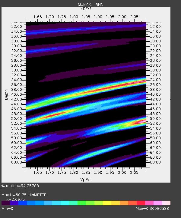
| Estimated Moho Depth: |
50.75 km |
| Estimated Crust Vp/Vs: |
2.10 |
| Assumed Crust Vp: |
6.566 km/s |
| Estimated Crust Vs: |
3.13 km/s |
| Estimated Crust Poisson's Ratio: |
0.35 |
|
| Radial Match: |
94.25788 % |
| Radial Bump: |
155 |
| Transverse Match: |
91.02103 % |
| Transverse Bump: |
171 |
| SOD ConfigId: |
2669 |
| Insert Time: |
2010-03-09 13:07:29.342 +0000 |
| GWidth: |
2.5 |
| Max Bumps: |
400 |
| Tol: |
0.001 |
|

Signal To Noise
| Channel | StoN | STA | LTA |
| AK:MCK: :BHN:20050718T02:19:55.640007Z | 1.4865283 | 1.3508271E-7 | 9.0871275E-8 |
| AK:MCK: :BHE:20050718T02:19:55.640007Z | 0.96956253 | 9.108868E-8 | 9.394822E-8 |
| AK:MCK: :BHZ:20050718T02:19:55.640007Z | 1.7332128 | 1.2283002E-7 | 7.0868396E-8 |
| Arrivals |
| Ps | 8.6 SECOND |
| PpPs | 24 SECOND |
| PsPs/PpSs | 32 SECOND |


