You are here: Home > Network List > N4 - Central and EAstern US Network Stations List
> Station U49A Red Boiling Springs, TN, USA > Earthquake Result Viewer
U49A Red Boiling Springs, TN, USA - Earthquake Result Viewer
| Earthquake location: |
Crete, Greece |
| Earthquake latitude/longitude: |
35.3/25.3 |
| Earthquake time(UTC): |
2021/09/27 (270) 06:17:22 GMT |
| Earthquake Depth: |
8.7 km |
| Earthquake Magnitude: |
6.0 mww |
| Earthquake Catalog/Contributor: |
NEIC PDE/us |
|
| Network: |
N4 Central and EAstern US Network |
| Station: |
U49A Red Boiling Springs, TN, USA |
| Lat/Lon: |
36.51 N/85.78 W |
| Elevation: |
234 m |
|
| Distance: |
84.0 deg |
| Az: |
310.887 deg |
| Baz: |
50.176 deg |
| Ray Param: |
0.045758862 |
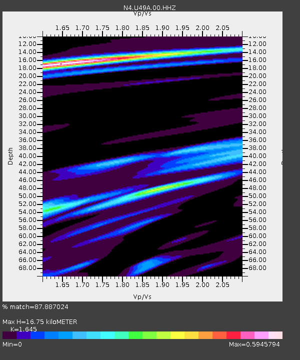
| Estimated Moho Depth: |
16.75 km |
| Estimated Crust Vp/Vs: |
1.64 |
| Assumed Crust Vp: |
6.476 km/s |
| Estimated Crust Vs: |
3.937 km/s |
| Estimated Crust Poisson's Ratio: |
0.21 |
|
| Radial Match: |
87.887024 % |
| Radial Bump: |
356 |
| Transverse Match: |
78.04929 % |
| Transverse Bump: |
400 |
| SOD ConfigId: |
25131211 |
| Insert Time: |
2021-10-11 06:34:35.521 +0000 |
| GWidth: |
2.5 |
| Max Bumps: |
400 |
| Tol: |
0.001 |
|

Signal To Noise
| Channel | StoN | STA | LTA |
| N4:U49A:00:HHZ:20210927T06:29:21.730011Z | 14.085439 | 1.2121717E-6 | 8.60585E-8 |
| N4:U49A:00:HH1:20210927T06:29:21.730011Z | 2.9481087 | 2.1615314E-7 | 7.331926E-8 |
| N4:U49A:00:HH2:20210927T06:29:21.730011Z | 4.640606 | 2.536084E-7 | 5.464984E-8 |
| Arrivals |
| Ps | 1.7 SECOND |
| PpPs | 6.7 SECOND |
| PsPs/PpSs | 8.4 SECOND |


