You are here: Home > Network List > N4 - Central and EAstern US Network Stations List
> Station W50A Signal Mountain, TN, USA > Earthquake Result Viewer
W50A Signal Mountain, TN, USA - Earthquake Result Viewer
| Earthquake location: |
Crete, Greece |
| Earthquake latitude/longitude: |
35.3/25.3 |
| Earthquake time(UTC): |
2021/09/27 (270) 06:17:22 GMT |
| Earthquake Depth: |
8.7 km |
| Earthquake Magnitude: |
6.0 mww |
| Earthquake Catalog/Contributor: |
NEIC PDE/us |
|
| Network: |
N4 Central and EAstern US Network |
| Station: |
W50A Signal Mountain, TN, USA |
| Lat/Lon: |
35.20 N/85.31 W |
| Elevation: |
587 m |
|
| Distance: |
84.6 deg |
| Az: |
309.631 deg |
| Baz: |
50.325 deg |
| Ray Param: |
0.04537852 |
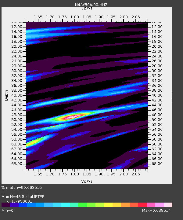
| Estimated Moho Depth: |
48.5 km |
| Estimated Crust Vp/Vs: |
1.80 |
| Assumed Crust Vp: |
6.35 km/s |
| Estimated Crust Vs: |
3.538 km/s |
| Estimated Crust Poisson's Ratio: |
0.27 |
|
| Radial Match: |
90.063515 % |
| Radial Bump: |
394 |
| Transverse Match: |
67.42686 % |
| Transverse Bump: |
400 |
| SOD ConfigId: |
25131211 |
| Insert Time: |
2021-10-11 06:34:42.984 +0000 |
| GWidth: |
2.5 |
| Max Bumps: |
400 |
| Tol: |
0.001 |
|

Signal To Noise
| Channel | StoN | STA | LTA |
| N4:W50A:00:HHZ:20210927T06:29:24.490021Z | 8.138005 | 7.99573E-7 | 9.825172E-8 |
| N4:W50A:00:HH1:20210927T06:29:24.490021Z | 1.7382612 | 1.7445342E-7 | 1.0036088E-7 |
| N4:W50A:00:HH2:20210927T06:29:24.490021Z | 2.3672628 | 1.6346458E-7 | 6.905214E-8 |
| Arrivals |
| Ps | 6.2 SECOND |
| PpPs | 21 SECOND |
| PsPs/PpSs | 27 SECOND |


