You are here: Home > Network List > US - United States National Seismic Network Stations List
> Station DGMT Dagmar, Montana, USA > Earthquake Result Viewer
DGMT Dagmar, Montana, USA - Earthquake Result Viewer
| Earthquake location: |
Crete, Greece |
| Earthquake latitude/longitude: |
35.3/25.3 |
| Earthquake time(UTC): |
2021/09/27 (270) 06:17:22 GMT |
| Earthquake Depth: |
8.7 km |
| Earthquake Magnitude: |
6.0 mww |
| Earthquake Catalog/Contributor: |
NEIC PDE/us |
|
| Network: |
US United States National Seismic Network |
| Station: |
DGMT Dagmar, Montana, USA |
| Lat/Lon: |
48.47 N/104.20 W |
| Elevation: |
0.0 m |
|
| Distance: |
85.3 deg |
| Az: |
328.961 deg |
| Baz: |
39.354 deg |
| Ray Param: |
0.044901483 |
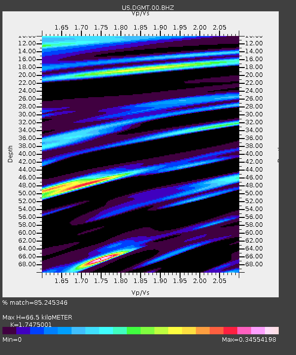
| Estimated Moho Depth: |
66.5 km |
| Estimated Crust Vp/Vs: |
1.75 |
| Assumed Crust Vp: |
6.438 km/s |
| Estimated Crust Vs: |
3.684 km/s |
| Estimated Crust Poisson's Ratio: |
0.26 |
|
| Radial Match: |
85.245346 % |
| Radial Bump: |
275 |
| Transverse Match: |
46.522873 % |
| Transverse Bump: |
389 |
| SOD ConfigId: |
25131211 |
| Insert Time: |
2021-10-11 06:42:07.034 +0000 |
| GWidth: |
2.5 |
| Max Bumps: |
400 |
| Tol: |
0.001 |
|
Signal To Noise
| Channel | StoN | STA | LTA |
| US:DGMT:00:BHZ:20210927T06:29:27.800018Z | 3.6476972 | 9.664782E-7 | 2.649557E-7 |
| US:DGMT:00:BH1:20210927T06:29:27.800018Z | 1.6579236 | 4.291734E-7 | 2.58862E-7 |
| US:DGMT:00:BH2:20210927T06:29:27.800018Z | 0.621687 | 2.886114E-7 | 4.6423906E-7 |
| Arrivals |
| Ps | 7.9 SECOND |
| PpPs | 28 SECOND |
| PsPs/PpSs | 36 SECOND |


