You are here: Home > Network List > CI - Caltech Regional Seismic Network Stations List
> Station SMM Simmler, CA, USA > Earthquake Result Viewer
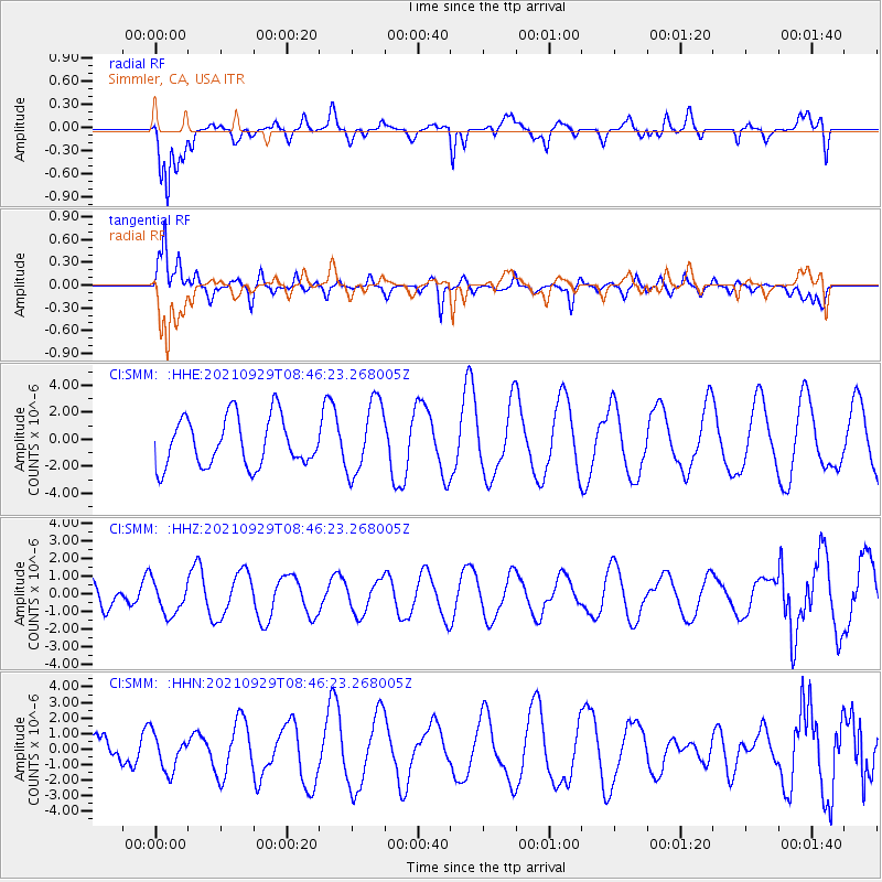
SMM Simmler, CA, USA - Earthquake Result Viewer
*The percent match for this event was below the threshold and hence no stack was calculated.
| Earthquake location: |
East Of Kuril Islands |
| Earthquake latitude/longitude: |
45.8/153.5 |
| Earthquake time(UTC): |
2021/09/29 (272) 08:37:05 GMT |
| Earthquake Depth: |
401 km |
| Earthquake Magnitude: |
6.5 Mi |
| Earthquake Catalog/Contributor: |
NEIC PDE/pt |
|
| Network: |
CI Caltech Regional Seismic Network |
| Station: |
SMM Simmler, CA, USA |
| Lat/Lon: |
35.31 N/120.00 W |
| Elevation: |
599 m |
|
| Distance: |
63.5 deg |
| Az: |
65.795 deg |
| Baz: |
308.721 deg |
| Ray Param: |
$rayparam |
*The percent match for this event was below the threshold and hence was not used in the summary stack. |
|
| Radial Match: |
47.068764 % |
| Radial Bump: |
400 |
| Transverse Match: |
71.49956 % |
| Transverse Bump: |
400 |
| SOD ConfigId: |
25131211 |
| Insert Time: |
2021-10-13 08:43:40.702 +0000 |
| GWidth: |
2.5 |
| Max Bumps: |
400 |
| Tol: |
0.001 |
|
Signal To Noise
| Channel | StoN | STA | LTA |
| CI:SMM: :HHZ:20210929T08:46:23.268005Z | 1.1738731 | 9.536315E-7 | 8.1238045E-7 |
| CI:SMM: :HHN:20210929T08:46:23.268005Z | 0.98740697 | 1.1952928E-6 | 1.2105371E-6 |
| CI:SMM: :HHE:20210929T08:46:23.268005Z | 1.491899 | 2.6925984E-6 | 1.8048127E-6 |
| Arrivals |
| Ps | |
| PpPs | |
| PsPs/PpSs | |


