You are here: Home > Network List > NM - Cooperative New Madrid Seismic Network Stations List
> Station HDAR2 I40 Weigh Station,West Memphis,AR > Earthquake Result Viewer
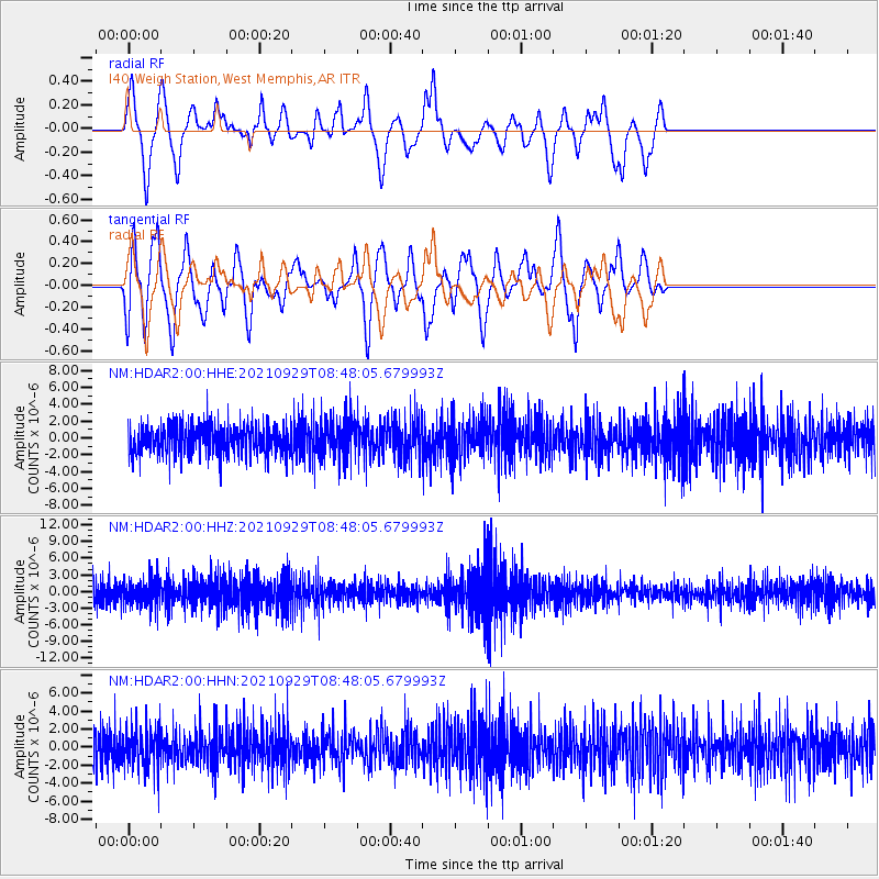
HDAR2 I40 Weigh Station,West Memphis,AR - Earthquake Result Viewer
*The percent match for this event was below the threshold and hence no stack was calculated.
| Earthquake location: |
East Of Kuril Islands |
| Earthquake latitude/longitude: |
45.8/153.5 |
| Earthquake time(UTC): |
2021/09/29 (272) 08:37:05 GMT |
| Earthquake Depth: |
401 km |
| Earthquake Magnitude: |
6.5 Mi |
| Earthquake Catalog/Contributor: |
NEIC PDE/pt |
|
| Network: |
NM Cooperative New Madrid Seismic Network |
| Station: |
HDAR2 I40 Weigh Station,West Memphis,AR |
| Lat/Lon: |
35.15 N/90.09 W |
| Elevation: |
100 m |
|
| Distance: |
81.1 deg |
| Az: |
47.974 deg |
| Baz: |
320.64 deg |
| Ray Param: |
$rayparam |
*The percent match for this event was below the threshold and hence was not used in the summary stack. |
|
| Radial Match: |
42.32676 % |
| Radial Bump: |
330 |
| Transverse Match: |
75.47251 % |
| Transverse Bump: |
400 |
| SOD ConfigId: |
25131211 |
| Insert Time: |
2021-10-13 08:50:00.430 +0000 |
| GWidth: |
2.5 |
| Max Bumps: |
400 |
| Tol: |
0.001 |
|
Signal To Noise
| Channel | StoN | STA | LTA |
| NM:HDAR2:00:HHZ:20210929T08:48:05.679993Z | 1.1412317 | 2.390016E-6 | 2.0942427E-6 |
| NM:HDAR2:00:HHN:20210929T08:48:05.679993Z | 1.0511353 | 2.1764254E-6 | 2.0705475E-6 |
| NM:HDAR2:00:HHE:20210929T08:48:05.679993Z | 1.3497285 | 2.3611851E-6 | 1.7493779E-6 |
| Arrivals |
| Ps | |
| PpPs | |
| PsPs/PpSs | |


